|
Forums59
Topics1,057,026
Posts14,278,669
Members144,601
| |
Most Online39,925
Dec 30th, 2023
|
|
 GPS Maps (North Texas Lakes)
#11651791
06/07/16 01:44 PM GPS Maps (North Texas Lakes)
#11651791
06/07/16 01:44 PM
|
Joined: May 2012
Posts: 92
ztitans1
 OP
OP
Outdoorsman
|
|
OP
Outdoorsman
Joined: May 2012
Posts: 92 |
Does anyone know of any GPS maps (or paper maps with coordinates) of North Texas area lakes? In particular I am looking to locate brush piles in Ray Roberts and the humps in Lewisville. Any advise would be greatly appreciated. Thanks in advance.
|
|
|
Re: GPS Maps (North Texas Lakes)
[Re: ztitans1]
#11651896
06/07/16 02:43 PM
|
Joined: Apr 2008
Posts: 10,550
JavelinJ
TFF Guru
|
|
TFF Guru
Joined: Apr 2008
Posts: 10,550 |
|
|
|
Re: GPS Maps (North Texas Lakes)
[Re: ztitans1]
#11651917
06/07/16 02:54 PM
|
Joined: Feb 2003
Posts: 1,622
Jacky Wiggins
Extreme Angler
|
|
Extreme Angler
Joined: Feb 2003
Posts: 1,622 |
Years back I bought a map from bass pro that had all the brush piles on Ray Roberts on it with coordinates. I remember asking the fishing counter for it and they had them in the back somewhere and not out on the shelf. Any topo map for your boat electronics or your phone will show you the humps on Lewisville. Navionics and aqua maps work well for those.
|
|
|
Re: GPS Maps (North Texas Lakes)
[Re: ztitans1]
#11651931
06/07/16 03:00 PM
|
Joined: Jan 2011
Posts: 1,615
Bassthumb: Phill's Guide Svc
Extreme Angler
|
|
Extreme Angler
Joined: Jan 2011
Posts: 1,615 |
I obtained the Ray Bob brush pile coords from someone on this forum a few years back. I punched them all into my old humminbird at the time and used them for several years. I just now thought about the guy who bought my old boat and graphs. He has a gold mine of crappie spots on lew and Ray Bob now.
If your fish finder has GPS I think your better off that way. Fishing ledges and humps is easier done with a GPS map on a fish finder if you ask me. if you want to do it on the cheap just download the navionics app on your phone. You can do the same thing with it.
|
|
|
Re: GPS Maps (North Texas Lakes)
[Re: ztitans1]
#11652291
06/07/16 05:33 PM
|
Joined: Sep 2008
Posts: 1,916
Tx Tree Grower
Extreme Angler
|
|
Extreme Angler
Joined: Sep 2008
Posts: 1,916 |
Download the navionics app to your phone. Its cheap and works pretty good. Its not as good as the map card you can load on your graph but it dang sure beats a paper map. I doubt you will find any map that has many brush piles listed on it. Those tend to be somewhat personal information.
|
|
|
Re: GPS Maps (North Texas Lakes)
[Re: ztitans1]
#11652737
06/07/16 09:05 PM
|
Joined: Nov 2006
Posts: 413
mbsfish
Angler
|
|
Angler
Joined: Nov 2006
Posts: 413 |
Some community shared spots on Navionics Webapp
Last edited by mbsfish; 06/07/16 09:08 PM.
|
|
|
Re: GPS Maps (North Texas Lakes)
[Re: ztitans1]
#11653250
06/08/16 01:14 AM
|
Joined: Dec 2012
Posts: 6,711
44 Diesel
TFF Celebrity
|
|
TFF Celebrity
Joined: Dec 2012
Posts: 6,711 |
Last edited by 44 Diesel; 06/08/16 01:15 AM.
|
|
|
Re: GPS Maps (North Texas Lakes)
[Re: ztitans1]
#11653752
06/08/16 06:21 AM
|
Joined: May 2012
Posts: 92
ztitans1
OP
Outdoorsman
|
|
OP
Outdoorsman
Joined: May 2012
Posts: 92 |
Great stuff. Thanks everyone!
|
|
|
Re: GPS Maps (North Texas Lakes)
[Re: ztitans1]
#11653753
06/08/16 06:28 AM
|
Joined: May 2012
Posts: 92
ztitans1
OP
Outdoorsman
|
|
OP
Outdoorsman
Joined: May 2012
Posts: 92 |
Funny I clicked on this Navionics Map and think I found those trees in 58' of water. I was trying to figure out what the heck I was dragging on when my line was only maybe 30' suspended below the boat (estimated).
I have a Lowrannce Elite 5. Do you think I should still also download Navionics?
|
|
|
Re: GPS Maps (North Texas Lakes)
[Re: ztitans1]
#11653862
06/08/16 12:21 PM
|
Joined: Apr 2008
Posts: 10,550
JavelinJ
TFF Guru
|
|
TFF Guru
Joined: Apr 2008
Posts: 10,550 |
Funny I clicked on this Navionics Map and think I found those trees in 58' of water. I was trying to figure out what the heck I was dragging on when my line was only maybe 30' suspended below the boat (estimated).
I have a Lowrannce Elite 5. Do you think I should still also download Navionics? I have a Humminbird 998C SI with Lakemaster and a Lowrance Elite 7....and still have the $9.99 Navionics phone app.
|
|
|
Re: GPS Maps (North Texas Lakes)
[Re: ztitans1]
#11653871
06/08/16 12:28 PM
|
Joined: Jan 2016
Posts: 586
Timmychanga
Pro Angler
|
|
Pro Angler
Joined: Jan 2016
Posts: 586 |
When I an just planing a trip at my desk I use this free online Navionics maps tool. Navionics online
|
|
|
Re: GPS Maps (North Texas Lakes)
[Re: JavelinJ]
#11654123
06/08/16 02:44 PM
|
Joined: Jan 2016
Posts: 18
Salty Sabine
Green Horn
|
|
Green Horn
Joined: Jan 2016
Posts: 18 |
Funny I clicked on this Navionics Map and think I found those trees in 58' of water. I was trying to figure out what the heck I was dragging on when my line was only maybe 30' suspended below the boat (estimated).
I have a Lowrannce Elite 5. Do you think I should still also download Navionics? I have a Humminbird 998C SI with Lakemaster and a Lowrance Elite 7.... [color:#FFFF66]and still have the $9.99 Navionics phone app. [/color] This....The detail and ability to study the maps which are constantly updated is priceless below is a quick screen shot of Ray Roberts on the App. 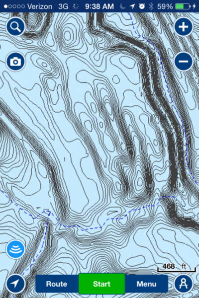
Last edited by Salty Sabine; 06/08/16 02:45 PM.
|
|
|
Re: GPS Maps (North Texas Lakes)
[Re: ztitans1]
#11654185
06/08/16 03:08 PM
|
Joined: Apr 2012
Posts: 1,809
I love fishing
Extreme Angler
|
|
Extreme Angler
Joined: Apr 2012
Posts: 1,809 |
|
|
Moderated by banker-always fishing, chickenman, Derek 🐝, Duck_Hunter, Fish Killer, J-2, Jacob, Jons3825, JustWingem, Nocona Brian, Toon-Troller, Uncle Zeek, Weekender1
|


![[Linked Image]](http://i.imgur.com/xPKie0ft.jpg)
![[Linked Image]](https://i.ibb.co/0FTRKJK/6.jpg)