|
Forums59
Topics1,057,393
Posts14,283,739
Members144,608
| |
Most Online39,925
Dec 30th, 2023
|
|
 Re: FALCON Update from Navionics!
[Re: Stumpjumper14]
#6477337
08/04/11 12:54 PM Re: FALCON Update from Navionics!
[Re: Stumpjumper14]
#6477337
08/04/11 12:54 PM
|
Joined: Jun 2004
Posts: 964
zorro

Pro Angler
|
|
Pro Angler
Joined: Jun 2004
Posts: 964 |
You need to check the second pic. It's completely wrong. There has never been water in the arm with all the red dots. What is this??
|
|
|
Re: FALCON Update from Navionics!
[Re: Jeff@Navionics]
#6477376
08/04/11 01:13 PM
|
Joined: May 2009
Posts: 7,110
horseplaydvm
TFF Celebrity
|
|
TFF Celebrity
Joined: May 2009
Posts: 7,110 |
How low was the lake when this survey was done? Is it the same as past chips? Completely diffent. The shoreline is much closer to the higher water levels that have encompasssed so much of the brush. The old map had you over dry land most of the time unless you were fishing mid-lake structure. However, if you guys don't get some rain soon... I just got back from there. The previous map was right on for the current water levels, so this new update will be show water where there is dry land now, or should I say ROCKS. So be careful if anyone uses the new software. I honestly prefer the old software because it shows where islands and humps are located if the water level is up. The new software just removed them and put blue water with no contour lines to let us know they were there. JMO
Last edited by horseplaydvm; 08/04/11 01:18 PM.
![[Linked Image]](http://i952.photobucket.com/albums/ae3/horseplaydvm/th_add70bd3.jpg) Gone Fishing B.A.S. 6/5/47-6/6/12 C.W.S. 9/29/72- 10/17/23
|
|
|
Re: FALCON Update from Navionics!
[Re: horseplaydvm]
#6477488
08/04/11 01:42 PM
|
Joined: May 2005
Posts: 4,582
ChampionDon (SkeeterDon)
TFF Team Angler
|
|
TFF Team Angler
Joined: May 2005
Posts: 4,582 |
Humminbird has the shaded depth offset, so if you know the lake is 25ft low, then just set at 25 ft and the shaded will be the shorline.
However I would have set it at 40 ft, so that I can see the humps/points in 15ft of h20.
|
|
|
Re: FALCON Update from Navionics!
[Re: ChampionDon (SkeeterDon)]
#6477724
08/04/11 02:38 PM
|
Joined: Jul 2004
Posts: 490
Jeff@Navionics
OP
Angler
|
|
OP
Angler
Joined: Jul 2004
Posts: 490 |
I'm not sure if any of you watched how we re-built the Lake Fork map recently. There are a number of threads if you want see the progession.
What needs to be considered, before making a final conclusion, is that this new release is one step in a multi-step process.
What was just released was a revamped shoreline that is a closer in reality than the previous one-Independent of water level. One cant know where the water level will be because maps aren't built in real-time (yet). Also in the release is a whole new layer of underwater features (which was the biggest request from the customer).
What is left is re-working the contours and shoreline so and discrepancies are fixed (the contours over land in one screen shot). This will take a bit longer, but the feedbach was that the new ma was more valuable than the old map. We didn't remove any "humps or contours", what we did do is put the water level to where it has been for the better part of the past 3 years (it should be close).
Obviously, nobody predicted the drought conditions you guys are facing...but, if you get rain...Its never going to be perfect.
Its really tough to make a call until it is actually used on the lake, I hope some of you that try the new map will report back here.
Its important for us to get it right and we value the feedback-just don't make a final conclusion yet. we aren't done.
Jeff@Navionics
"Take a kid Fishing"
|
|
|
Re: FALCON Update from Navionics!
[Re: SkeeterJim]
#6477740
08/04/11 02:41 PM
|
Joined: Jul 2004
Posts: 490
Jeff@Navionics
OP
Angler
|
|
OP
Angler
Joined: Jul 2004
Posts: 490 |
Why aren't there any contour lines with the new data? It looks as if you just added blue to reflect water to a different contour line. Because accurate depths for those areas don't exist, yet. What the blue shows SHOULD be the areas covered at that pool level and any structure that would be covered. If you don't see spot soundings/depts, it usually means its a shallow (or possibly dry) area. Proceed with caution.
Jeff@Navionics
"Take a kid Fishing"
|
|
|
Re: FALCON Update from Navionics!
[Re: N-M-W]
#6477771
08/04/11 02:49 PM
|
Joined: Jul 2004
Posts: 490
Jeff@Navionics
OP
Angler
|
|
OP
Angler
Joined: Jul 2004
Posts: 490 |
Jeff;
How can you tell if a new chip, that is still in the package, is rewritable? Will the packaging state that on the outside?
Bobzilla +100.....My question exactly. How do we know if its made after last October? There shouldn't be any HotMap Premium or Platinum charts left on shelves that were produced before last OCT. The chart code will be MSD/HMPT-S6 or MSD/PREM-S6. If there is a number lower than "6" after the S, it should be in the clearance bin because its not a current chart.
Jeff@Navionics
"Take a kid Fishing"
|
|
|
Re: FALCON Update from Navionics!
[Re: ChampionDon (SkeeterDon)]
#6477830
08/04/11 03:05 PM
|
Joined: May 2009
Posts: 7,110
horseplaydvm
TFF Celebrity
|
|
TFF Celebrity
Joined: May 2009
Posts: 7,110 |
Humminbird has the shaded depth offset, so if you know the lake is 25ft low, then just set at 25 ft and the shaded will be the shorline.
However I would have set it at 40 ft, so that I can see the humps/points in 15ft of h20. Lowrance HDS has that too. You can have two different shaded depths, but the Navioncs card is what puts the island, humps, contour lines on there.
Gone Fishing B.A.S. 6/5/47-6/6/12 C.W.S. 9/29/72- 10/17/23
|
|
|
Re: FALCON Update from Navionics!
[Re: horseplaydvm]
#6477907
08/04/11 03:24 PM
|
Joined: Sep 2006
Posts: 2,882
Tracker Tim
Extreme Angler
|
|
Extreme Angler
Joined: Sep 2006
Posts: 2,882 |
I just updated mine. It only took 8 minutes.
|
|
|
Re: FALCON Update from Navionics!
[Re: Tracker Tim]
#6500676
08/10/11 04:54 PM
|
Joined: Jul 2004
Posts: 490
Jeff@Navionics
OP
Angler
|
|
OP
Angler
Joined: Jul 2004
Posts: 490 |
Here are a few more screen shots of the newest data available for download on Premium and Platinum charts for Falcon (must have been purchased since last OCT to get this content). We looked closely at the new vs. old data. Agreed the water levels are a challenge (blue with no contour lines means it is an area that "covers and uncovers" with current lake elevation). Last year it was nuts on, this year it will show as higher than what exists (we didn't forcast century high drought conditions-were good, but...). Compare it to historic Google imagery-Its VERY good and far more accurate than the previous (current) map. When we have a "pool level adjustment" tool live (shhhhh-and dont ask when) it will be easy to manage this coloration to reflect actual conditions. The key differences are; you shouldn't find yourself on land anymore, underwater structures (LOTS of new data), and an enhanced shoreline. Contours are being re-worked for the next release-remember, this is a continuing process. In all, the conclusion is that (even while not "perfect"-which nothing is in maping) its a great update for the Falcon angler. The first shot in the series is the "old" map, the second is what is available today for upload 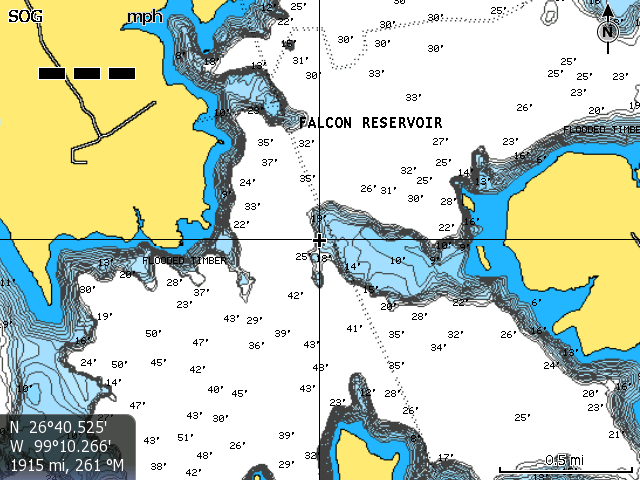 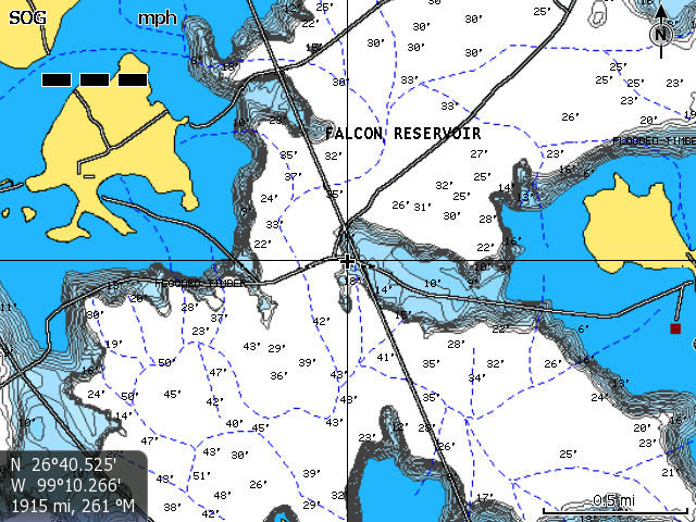   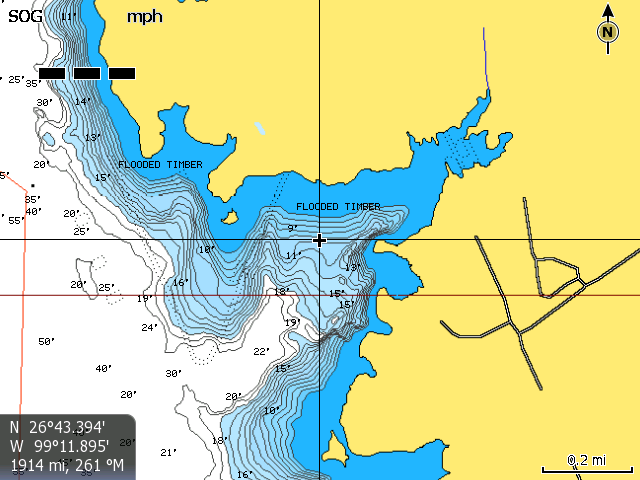 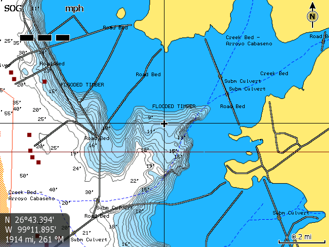   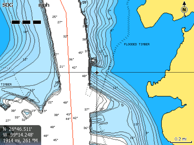 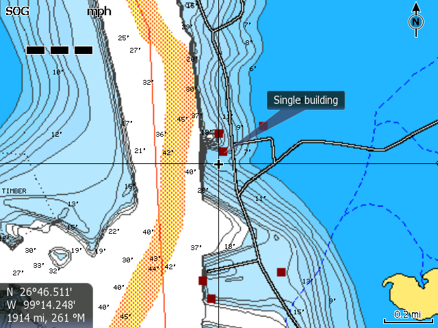
Jeff@Navionics
"Take a kid Fishing"
|
|
|
Re: FALCON Update from Navionics!
[Re: Jeff@Navionics]
#6501719
08/10/11 08:18 PM
|
Joined: May 2009
Posts: 7,110
horseplaydvm
TFF Celebrity
|
|
TFF Celebrity
Joined: May 2009
Posts: 7,110 |
Jeff, the structure is definitely better on the update. But for example, in the first pic above there are two islands on the right hand side and they don't show up in the updated version. I whacked em on that spot a few weeks ago and if Im looking on the new software for humps or islands to fish then I would have missed those. Good thing I have an older version and Insight on my Lowrance to see differences.
Gone Fishing B.A.S. 6/5/47-6/6/12 C.W.S. 9/29/72- 10/17/23
|
|
|
Re: FALCON Update from Navionics!
[Re: horseplaydvm]
#6501906
08/10/11 08:53 PM
|
Joined: Jul 2004
Posts: 490
Jeff@Navionics
OP
Angler
|
|
OP
Angler
Joined: Jul 2004
Posts: 490 |
I see your point, but the area isnt surveyed so we dont know the depths and can't just "guess". I would guess those islands were covered two seasons ago and still didn't exist on anyones map. The good news is that the next version will address some of the shallower water contouring. We are also looking at offering more than one coastline. One thing that would help is using the UGC function on our mobile products to share the info or by new actual sonar recordings of the shallower areas (If anyone wants to help...). Its great feedback though. My product manager and I just spent 1/2 hour discussing it! Ya...we love maps 
Jeff@Navionics
"Take a kid Fishing"
|
|
|
Re: FALCON Update from Navionics!
[Re: horseplaydvm]
#6501944
08/10/11 08:59 PM
|
Joined: Apr 2008
Posts: 3,906
JPost
TFF Team Angler
|
|
TFF Team Angler
Joined: Apr 2008
Posts: 3,906 |
That's interesting. It looks like those 2 islands are really road beds. They were under water during the survey and now I'm sure they're exposed again.
|
|
|
Re: FALCON Update from Navionics!
[Re: JPost]
#6501964
08/10/11 09:03 PM
|
Joined: Jan 2007
Posts: 6,749
Jersey Dan
Guido
|
|
Guido
Joined: Jan 2007
Posts: 6,749 |
Jeff - When was this last Falcon update released? I downloaded the updated Navionics two weeks ago, just wanted to make sure I have not missed another version. Thanks...
|
|
|
Re: FALCON Update from Navionics!
[Re: JPost]
#6501972
08/10/11 09:04 PM
|
Joined: May 2009
Posts: 7,110
horseplaydvm
TFF Celebrity
|
|
TFF Celebrity
Joined: May 2009
Posts: 7,110 |
Thanks Jeff! Looking forward to that updated software in the works!
JPost, yes there is a roadbed close, but those islands are still submerged but not for long if we don't get some rain.
Gone Fishing B.A.S. 6/5/47-6/6/12 C.W.S. 9/29/72- 10/17/23
|
|
|
Re: FALCON Update from Navionics!
[Re: Jersey Dan]
#6501990
08/10/11 09:07 PM
|
Joined: Jul 2004
Posts: 490
Jeff@Navionics
OP
Angler
|
|
OP
Angler
Joined: Jul 2004
Posts: 490 |
Jeff - When was this last Falcon update released? I downloaded the updated Navionics two weeks ago, just wanted to make sure I have not missed another version. Thanks... Monday before last...You can update it again if you want to be sure
Jeff@Navionics
"Take a kid Fishing"
|
|
Moderated by banker-always fishing, chickenman, Derek 🐝, Duck_Hunter, Fish Killer, J-2, Jacob, Jons3825, JustWingem, Nocona Brian, Toon-Troller, Uncle Zeek, Weekender1
|
![[Linked Image]](http://s952.photobucket.com/albums/ae3/horseplaydvm/?action=view�t=add70bd3.jpg)