|
Forums59
Topics1,057,038
Posts14,278,897
Members144,601
| |
Most Online39,925
Dec 30th, 2023
|
|
 marking a w/p on the dsi models
#5792521
02/02/11 02:22 AM marking a w/p on the dsi models
#5792521
02/02/11 02:22 AM
|
Joined: Jan 2010
Posts: 60
basscatmark
 OP
OP
Outdoorsman
|
|
OP
Outdoorsman
Joined: Jan 2010
Posts: 60 |
When marking a w/p on the down imaging models, in either brand , If I go over a stump and go to mark a w/p is there anyway to know where that stump is in the beam as far as where it is from the actual w/p? I know it is dependent on the depth of water.
thnx
mark
|
|
|
Re: marking a w/p on the dsi models
[Re: basscatmark]
#5792617
02/02/11 02:39 AM
|
Joined: Jul 2003
Posts: 3,290
Jason Gilstrap
Mr. Lowrance
|
|
Mr. Lowrance
Joined: Jul 2003
Posts: 3,290 |
On the Lowrance DSI esp. the Elite 5 DSI TrackBack� Into Sonar History Enjoy immediate scroll-back of imaging sonar history to review covered water and pinpoint spots (saves time and fuel trying to re-trace your path). With Elite-5 DSI, mark a waypoint at your cursor location with a simple press of a button. http://www.lowrance.com/Products/Marine/Mark-Elite-Series/Elite-5-DSI/
Last edited by Jason Gilstrap; 02/02/11 02:40 AM.
|
|
|
Re: marking a w/p on the dsi models
[Re: Jason Gilstrap]
#5792657
02/02/11 02:46 AM
|
Joined: Jan 2010
Posts: 60
basscatmark
OP
Outdoorsman
|
|
OP
Outdoorsman
Joined: Jan 2010
Posts: 60 |
Jason I know that but when you set a w/p on 2d or downscan it is a linear picture, that is fine if the stump is right dead under the boat but how bout if it is 20 ft off to the side " again depending on depth" With the 455/ 800 freguency you are covering some 80 degrees from the center line of the boat,How can you tell where that stump is in relation to the w/p for sure?
mark
mark
|
|
|
Re: marking a w/p on the dsi models
[Re: basscatmark]
#5793100
02/02/11 04:30 AM
|
Joined: Jul 2003
Posts: 3,290
Jason Gilstrap
Mr. Lowrance
|
|
Mr. Lowrance
Joined: Jul 2003
Posts: 3,290 |
Is the information that you are wanting. As for the wpt. the Govt. has limitation how accurate public GPS is. So that can vary. On any brand with GPS there can be 3-15ft error on your position. So that could make your wpt off to your target. 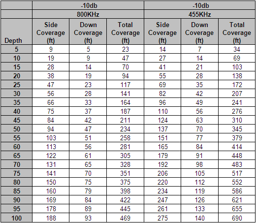
Last edited by Jason Gilstrap; 02/02/11 04:34 AM.
|
|
|
Re: marking a w/p on the dsi models
[Re: Jason Gilstrap]
#5793138
02/02/11 04:42 AM
|
Joined: Jan 2010
Posts: 60
basscatmark
OP
Outdoorsman
|
|
OP
Outdoorsman
Joined: Jan 2010
Posts: 60 |
Here is what I mean, we will use the chart lets say I am using d/s in 455kz in 20ft. of water I go over a stump on the screen and mark a w/p, according to the chart at that depth there is 28ft. of bottom coverage, my question is how do you know if the stump is right under the boat or 6ft to the left or 14ft. to the right, or something in-betwwen?
thnx
mark
|
|
|
Re: marking a w/p on the dsi models
[Re: basscatmark]
#5793188
02/02/11 04:58 AM
|
Joined: Jul 2003
Posts: 3,290
Jason Gilstrap
Mr. Lowrance
|
|
Mr. Lowrance
Joined: Jul 2003
Posts: 3,290 |
On 2D sonar you can go by the returns. (brighter color return means more in the apex of the cone. If's more dark blue or dark colors it means its outside the apex cone. You don't know where actually is. if's left, right and front or back of you.
Use the flash light as example as your cone on your 2d sonar.
As for Down scan, I all know its a knife like cut that cut water column in 3 degree. and it press much right under you. because of the cone and is very small.
Last edited by Jason Gilstrap; 02/02/11 04:59 AM.
|
|
Moderated by banker-always fishing, chickenman, Derek 🐝, Duck_Hunter, Fish Killer, J-2, Jacob, Jons3825, JustWingem, Nocona Brian, Toon-Troller, Uncle Zeek, Weekender1
|
