|
Forums59
Topics1,057,665
Posts14,288,554
Members144,611
| |
Most Online39,925
Dec 30th, 2023
|
|
 Lake Bridgeport - Defining Terms
#12877558
08/27/18 01:41 AM Lake Bridgeport - Defining Terms
#12877558
08/27/18 01:41 AM
|
Joined: Jul 2011
Posts: 4,218
David Burton
 OP
OP
TFF Team Angler
|
|
OP
TFF Team Angler
Joined: Jul 2011
Posts: 4,218 |
Is the entire upper end of Bridgeport considered ōThe Riverö, just the main channel, just the extremities, something else? Here is the map and what I am asking about. 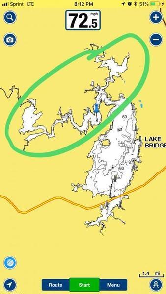
David Burton
2015 Skeeter FX 21 +Ultrex +Helix 12 (x3) +Mega360 +MegaLive
|
|
 Re: Lake Bridgeport - Defining Terms
[Re: David Burton]
#12877560
08/27/18 01:46 AM Re: Lake Bridgeport - Defining Terms
[Re: David Burton]
#12877560
08/27/18 01:46 AM
|
Joined: May 2014
Posts: 7,737
GIG'EM AGGIES
TFF Celebrity
|
|
TFF Celebrity
Joined: May 2014
Posts: 7,737 |
Is the entire upper end of Bridgeport considered ōThe Riverö, just the main channel, just the extremities, something else? Here is the map and what I am asking about. Your pin is marking the West Fork of the Trinity which is referred to as " the river ". The wide open area south of there would be called the lake or at least that's how I view it.
I am a Senager. (Senior teenager) I have everything that I wanted as a teenager, only 50 years later. I get an allowance every month. I have PU truck and a bass boat, I am blessed.
Conscience never acquits, it either accuses or excuses.
|
|
|
Re: Lake Bridgeport - Defining Terms
[Re: David Burton]
#12877626
08/27/18 03:05 AM
|
Joined: Jan 2008
Posts: 20,159
Donald Harper

TFF Guru
|
|
TFF Guru
Joined: Jan 2008
Posts: 20,159 |
Once you leave the main lake and head up the river, I refer to that section as the River Basin. You will find that most have begun to collect silt and are very shallow at the mouth of the actual river. Don't let that discourage you as there are resident fish that live in the river system. Find access to the river off the next highway that crosses the river. Using a smaller boat and working all the lay-down off the river banks. It is a wonderful trip for the fall of the year when the water begins to cool down some. Many times lake levels prevent us from getting into the river system from the main lake. Many times the water is off color that turns many fisherman away. Going as far away as you can get is a good thing and will pay off. I have made the run many times on many lakes through two foot of water to get into the back country river system during tournaments over the years. It is much safer to go up river to access spots when the rules allow trailing. Once up the river system a couple of miles the water will clear and become much deeper. Wind and Beaver put the lay-downs off the heavily timbered river banks into the water, making for super targets holding some good fish.
Each person you work with holds some promise to your future success. Websiite Sponsors: www.eletewater.com - Staying Hydrated www.lakeoviachic.com - Booking Mexico Trips 20 Hot Spot Mapping - GPS Contour Chips - Custom Spinner Baits - Jigs -Spooks Pure Extracts - Minnow-Night Crawler-Crayfish-Craylic
|
|
|
Re: Lake Bridgeport - Defining Terms
[Re: David Burton]
#12879949
08/29/18 03:02 AM
|
Joined: Jan 2011
Posts: 447
Jumpin J
Angler
|
|
Angler
Joined: Jan 2011
Posts: 447 |
The actual West Fork Trinity arm, is the portion winding to the West. The Northern branch, above Chico Ramp, is just a secondary feeder creek, from Jack County.
|
|
|
Re: Lake Bridgeport - Defining Terms
[Re: Jumpin J]
#12879962
08/29/18 03:15 AM
|
Joined: Jul 2011
Posts: 4,218
David Burton
OP
TFF Team Angler
|
|
OP
TFF Team Angler
Joined: Jul 2011
Posts: 4,218 |
The actual West Fork Trinity arm, is the portion winding to the West. The Northern branch, above Chico Ramp, is just a secondary feeder creek, from Jack County. Thanks for confirming. I see that it flows from WNW to ESE and empties at mid-lake. That's exactly what I was looking for. Not any details needed, just trying to classify my fishing locations as 'river', 'creek', or 'lake'. Even though there was an obvious "Main Lake", I keep hearing that you have to decide to either fish the 'River' or 'Lake'. The run to the bridge is fairly easy, even in a moderate wind from the south.
David Burton
2015 Skeeter FX 21 +Ultrex +Helix 12 (x3) +Mega360 +MegaLive
|
|
|
Re: Lake Bridgeport - Defining Terms
[Re: Donald Harper]
#12879967
08/29/18 03:28 AM
|
Joined: Jan 2004
Posts: 74,867
Mark Perry

Super Freak
|
|
Super Freak
Joined: Jan 2004
Posts: 74,867 |
Once you leave the main lake and head up the river, I refer to that section as the River Basin. You will find that most have begun to collect silt and are very shallow at the mouth of the actual river. Don't let that discourage you as there are resident fish that live in the river system. Find access to the river off the next highway that crosses the river. Using a smaller boat and working all the lay-down off the river banks. It is a wonderful trip for the fall of the year when the water begins to cool down some. Many times lake levels prevent us from getting into the river system from the main lake. Many times the water is off color that turns many fisherman away. Going as far away as you can get is a good thing and will pay off. I have made the run many times on many lakes through two foot of water to get into the back country river system during tournaments over the years. It is much safer to go up river to access spots when the rules allow trailing. Once up the river system a couple of miles the water will clear and become much deeper. Wind and Beaver put the lay-downs off the heavily timbered river banks into the water, making for super targets holding some good fish. Have you ever been in the river area of Bridgeport?
|
|
|
Re: Lake Bridgeport - Defining Terms
[Re: Mark Perry]
#12880049
08/29/18 10:50 AM
|
Joined: May 2014
Posts: 7,737
GIG'EM AGGIES
TFF Celebrity
|
|
TFF Celebrity
Joined: May 2014
Posts: 7,737 |
Once you leave the main lake and head up the river, I refer to that section as the River Basin. You will find that most have begun to collect silt and are very shallow at the mouth of the actual river. Don't let that discourage you as there are resident fish that live in the river system. Find access to the river off the next highway that crosses the river. Using a smaller boat and working all the lay-down off the river banks. It is a wonderful trip for the fall of the year when the water begins to cool down some. Many times lake levels prevent us from getting into the river system from the main lake. Many times the water is off color that turns many fisherman away. Going as far away as you can get is a good thing and will pay off. I have made the run many times on many lakes through two foot of water to get into the back country river system during tournaments over the years. It is much safer to go up river to access spots when the rules allow trailing. Once up the river system a couple of miles the water will clear and become much deeper. Wind and Beaver put the lay-downs off the heavily timbered river banks into the water, making for super targets holding some good fish. Have you ever been in the river area of Bridgeport? I think he's talking about a different part of the "river" than we are Mark. There is a bridge over the river farther west but you can't enter the river there. I think that road is called Coca Cola Ranch Rd. The entrance to the West Fork of the river from the main lake is very deep and his description doesn't match it. Once you get past Beans Creek the water does muddy up though. Some people think the area north of Wise County Park is the "river" but it is not. David has clearly pinned the river.
I am a Senager. (Senior teenager) I have everything that I wanted as a teenager, only 50 years later. I get an allowance every month. I have PU truck and a bass boat, I am blessed.
Conscience never acquits, it either accuses or excuses.
|
|
|
Re: Lake Bridgeport - Defining Terms
[Re: GIG'EM AGGIES]
#12880123
08/29/18 12:34 PM
|
Joined: Jul 2011
Posts: 5,438
Dubee
TFF Celebrity
|
|
TFF Celebrity
Joined: Jul 2011
Posts: 5,438 |
Once you leave the main lake and head up the river, I refer to that section as the River Basin. You will find that most have begun to collect silt and are very shallow at the mouth of the actual river. Don't let that discourage you as there are resident fish that live in the river system. Find access to the river off the next highway that crosses the river. Using a smaller boat and working all the lay-down off the river banks. It is a wonderful trip for the fall of the year when the water begins to cool down some. Many times lake levels prevent us from getting into the river system from the main lake. Many times the water is off color that turns many fisherman away. Going as far away as you can get is a good thing and will pay off. I have made the run many times on many lakes through two foot of water to get into the back country river system during tournaments over the years. It is much safer to go up river to access spots when the rules allow trailing. Once up the river system a couple of miles the water will clear and become much deeper. Wind and Beaver put the lay-downs off the heavily timbered river banks into the water, making for super targets holding some good fish. Have you ever been in the river area of Bridgeport? I think he's talking about a different part of the "river" than we are Mark. There is a bridge over the river farther west but you can't enter the river there. I think that road is called Coca Cola Ranch Rd. The entrance to the West Fork of the river from the main lake is very deep and his description doesn't match it. Once you get past Beans Creek the water does muddy up though. Some people think the area north of Wise County Park is the "river" but it is not. David has clearly pinned the river. He's not even talking about Bridgeport. Just giving a generic answer about rivers.
|
|
|
Re: Lake Bridgeport - Defining Terms
[Re: Dubee]
#12880127
08/29/18 12:38 PM
|
Joined: May 2014
Posts: 7,737
GIG'EM AGGIES
TFF Celebrity
|
|
TFF Celebrity
Joined: May 2014
Posts: 7,737 |
Well the topic was Lake Bridgeport so I just assumed .............
I am a Senager. (Senior teenager) I have everything that I wanted as a teenager, only 50 years later. I get an allowance every month. I have PU truck and a bass boat, I am blessed.
Conscience never acquits, it either accuses or excuses.
|
|
|
Re: Lake Bridgeport - Defining Terms
[Re: David Burton]
#12880177
08/29/18 01:11 PM
|
Joined: Feb 2009
Posts: 45
great catch
Outdoorsman
|
|
Outdoorsman
Joined: Feb 2009
Posts: 45 |
"Is the entire upper end of Bridgeport considered ōThe Riverö, just the main channel, just the extremities, something else?"
I would think he's asking about Bridgeport.
I know there is confusion about the river but the main river channel in Bridgeport is the Trinity and it is the arm he marked.
|
|
|
Re: Lake Bridgeport - Defining Terms
[Re: great catch]
#12880189
08/29/18 01:24 PM
|
Joined: May 2014
Posts: 7,737
GIG'EM AGGIES
TFF Celebrity
|
|
TFF Celebrity
Joined: May 2014
Posts: 7,737 |
"Is the entire upper end of Bridgeport considered ōThe Riverö, just the main channel, just the extremities, something else?"
I would think he's asking about Bridgeport.
I know there is confusion about the river but the main river channel in Bridgeport is the Trinity and it is the arm he marked.
You got it right GC, he's asking about the "river" at Bridgeport which is the West Fork of the Trinity and he clearly has it marked. The area around Wise County park and northward is not the "river" but some feeder creeks.
I am a Senager. (Senior teenager) I have everything that I wanted as a teenager, only 50 years later. I get an allowance every month. I have PU truck and a bass boat, I am blessed.
Conscience never acquits, it either accuses or excuses.
|
|
|
Re: Lake Bridgeport - Defining Terms
[Re: GIG'EM AGGIES]
#12881172
08/30/18 02:18 AM
|
Joined: Jan 2004
Posts: 74,867
Mark Perry
Super Freak
|
|
Super Freak
Joined: Jan 2004
Posts: 74,867 |
Once you leave the main lake and head up the river, I refer to that section as the River Basin. You will find that most have begun to collect silt and are very shallow at the mouth of the actual river. Don't let that discourage you as there are resident fish that live in the river system. Find access to the river off the next highway that crosses the river. Using a smaller boat and working all the lay-down off the river banks. It is a wonderful trip for the fall of the year when the water begins to cool down some. Many times lake levels prevent us from getting into the river system from the main lake. Many times the water is off color that turns many fisherman away. Going as far away as you can get is a good thing and will pay off. I have made the run many times on many lakes through two foot of water to get into the back country river system during tournaments over the years. It is much safer to go up river to access spots when the rules allow trailing. Once up the river system a couple of miles the water will clear and become much deeper. Wind and Beaver put the lay-downs off the heavily timbered river banks into the water, making for super targets holding some good fish. Have you ever been in the river area of Bridgeport? I think he's talking about a different part of the "river" than we are Mark. There is a bridge over the river farther west but you can't enter the river there. I think that road is called Coca Cola Ranch Rd. The entrance to the West Fork of the river from the main lake is very deep and his description doesn't match it. Once you get past Beans Creek the water does muddy up though. Some people think the area north of Wise County Park is the "river" but it is not. David has clearly pinned the river. I lived out there and have fished it regularly for many year. I think I have seen every rock on that lake at least once.....  ..... Not sure where he is talking about but I agree I think its a generic answer as it really does not fit Bridgeport. The area up near Wise County Park is Big Creek and yes it gets referred to as the river quite often. If you know the way you can run on pad way up past the old bridge up there but i do not reccomend it right now at that level the lake is at.
|
|
|
Re: Lake Bridgeport - Defining Terms
[Re: David Burton]
#12881852
08/30/18 05:52 PM
|
Joined: Oct 2013
Posts: 624
DEFMP
Pro Angler
|
|
Pro Angler
Joined: Oct 2013
Posts: 624 |
Is Wise County Ramp deep enough to launch at right now? Will I be able to get down south with the lake being this low?
|
|
|
Re: Lake Bridgeport - Defining Terms
[Re: DEFMP]
#12881854
08/30/18 05:54 PM
|
Joined: Jan 2004
Posts: 74,867
Mark Perry
Super Freak
|
|
Super Freak
Joined: Jan 2004
Posts: 74,867 |
Is Wise County Ramp deep enough to launch at right now? Will I be able to get down south with the lake being this low? Yes. Plus there will be the low water ramps there on the point too. When lake gets low you will see the ramps on the point.
|
|
|
Re: Lake Bridgeport - Defining Terms
[Re: Mark Perry]
#12882237
08/30/18 11:05 PM
|
Joined: Jul 2011
Posts: 4,218
David Burton
OP
TFF Team Angler
|
|
OP
TFF Team Angler
Joined: Jul 2011
Posts: 4,218 |
Is Wise County Ramp deep enough to launch at right now? Will I be able to get down south with the lake being this low? Yes. Plus there will be the low water ramps there on the point too. When lake gets low you will see the ramps on the point. Easy navigation! The channel from the ramps is 8-12 foot. NavionicsÆ lack of data is what concerned me, but we are all good!
David Burton
2015 Skeeter FX 21 +Ultrex +Helix 12 (x3) +Mega360 +MegaLive
|
|
Moderated by banker-always fishing, chickenman, Derek ¤ÉØ, Duck_Hunter, Fish Killer, J-2, Jacob, Jons3825, JustWingem, Nocona Brian, Toon-Troller, Uncle Zeek, Weekender1
|