|
Forums59
Topics1,053,788
Posts14,224,744
Members144,522
| |
Most Online39,925
Dec 30th, 2023
|
|
 Learning to use a topo map
#8592075
02/15/13 01:06 AM Learning to use a topo map
#8592075
02/15/13 01:06 AM
|
Joined: Sep 2012
Posts: 1,332
Kayak_and_Crossbones
 OP
OP
Extreme Angler
|
|
OP
Extreme Angler
Joined: Sep 2012
Posts: 1,332 |
I've heard that mapping out your "plan of attack" based on a topo map is the best way to approach a larger body of water. I'm 10 minutes from Marine Creek Lake, and really enjoy fishing it...but I have no idea how to read this topo map.(below) I understand how the lines indicate a slope...but that doesn't mean that I understand the best way to approach fishing the lake. I would really appreciate a lesson in Topo Reading 101. http://www.trails.com/topo.aspx?lat=32.8...eek%20Reservoir(From what I see, there isn't much info on this map.)
|
|
|
Re: Learning to use a topo map
[Re: Kayak_and_Crossbones]
#8592090
02/15/13 01:09 AM
|
Joined: Jun 2005
Posts: 23,930
Nocona Brian
TFF Guru
|
|
TFF Guru
Joined: Jun 2005
Posts: 23,930 |
Thats a difficult map to look at, shows prett much what you could see by looking at the slope of the bank and assuming what it'd do once it goes under water. Let me see if I can get you a better map.
|
|
|
Re: Learning to use a topo map
[Re: Kayak_and_Crossbones]
#8592140
02/15/13 01:20 AM
|
Joined: Jun 2005
Posts: 23,930
Nocona Brian
TFF Guru
|
|
TFF Guru
Joined: Jun 2005
Posts: 23,930 |
Well best I can do is the same map you have but bigger and easier to see. Merry Christmas... IF you want to find whats down there, get that google going and find one from before the lake was impounded. Could take several hours. 
|
|
|
Re: Learning to use a topo map
[Re: Kayak_and_Crossbones]
#8592241
02/15/13 01:39 AM
|
Joined: Jan 2007
Posts: 1,100
The Thorpedo
Extreme Angler
|
|
Extreme Angler
Joined: Jan 2007
Posts: 1,100 |
Map is really difficult to read compared to navionics but fairly accurate from what I've see of the lake when I've been there. Being that the dam is the south end it kind of shows with lines that's there's a deep creek channel that hangs tight to the east bank and goes up into the very north end. It stands true because last time I fished the north end it would go from 3 feet deep on either side then drop straight to 8. It also shows you how drastic the depth change is on the points and how quickly it gets deep near the south east ramp. I've found drastic or quick changes in depth tend to always hold fish. Better detailed maps like navionics pain an even better picture.
THE KAYAK KID
History of kayaks
Perception-pescador12
Native-Mariner
Wildernesssystems-ride115
|
|
|
Re: Learning to use a topo map
[Re: Kayak_and_Crossbones]
#8592283
02/15/13 01:47 AM
|
Joined: Aug 2008
Posts: 11,592
DEERSTRANGLER�
TFF Guru
|
|
TFF Guru
Joined: Aug 2008
Posts: 11,592 |
Topo maps are good to check briefly but I generally look where the wind is blowing. Wind blown points and cuts are the best starting places.
|
|
|
Re: Learning to use a topo map
[Re: DEERSTRANGLER�]
#8592531
02/15/13 02:31 AM
|
Joined: Nov 2011
Posts: 68
jake100
Outdoorsman
|
|
Outdoorsman
Joined: Nov 2011
Posts: 68 |
The closer together the lines are the steeper the dropoff the lines will be in 10 ft incerments or what ever is listed in the legand or look at the dark lines they will have an elevation listing somewhere on that line. jake (that one is 10')
Last edited by jake100; 02/15/13 02:35 AM.
|
|
|
Re: Learning to use a topo map
[Re: Kayak_and_Crossbones]
#8592953
02/15/13 04:15 AM
|
Joined: Jun 2005
Posts: 23,930
Nocona Brian
TFF Guru
|
|
TFF Guru
Joined: Jun 2005
Posts: 23,930 |
This might help alittle. Take this little section of Lake Worth, the closer the lines are to each other the steeper the slope. On a more detailed map, it'll show humps, channels and other structures. Ridges and valleys will look the same, you just have to look at the number at the center of the lines and compare it to whats next to it to decide whether or not its a hole or a ledge. As for offshore fishing, the places I would look for would be areas where there is a steep change in the bottom, be it a hump, or a ledge. 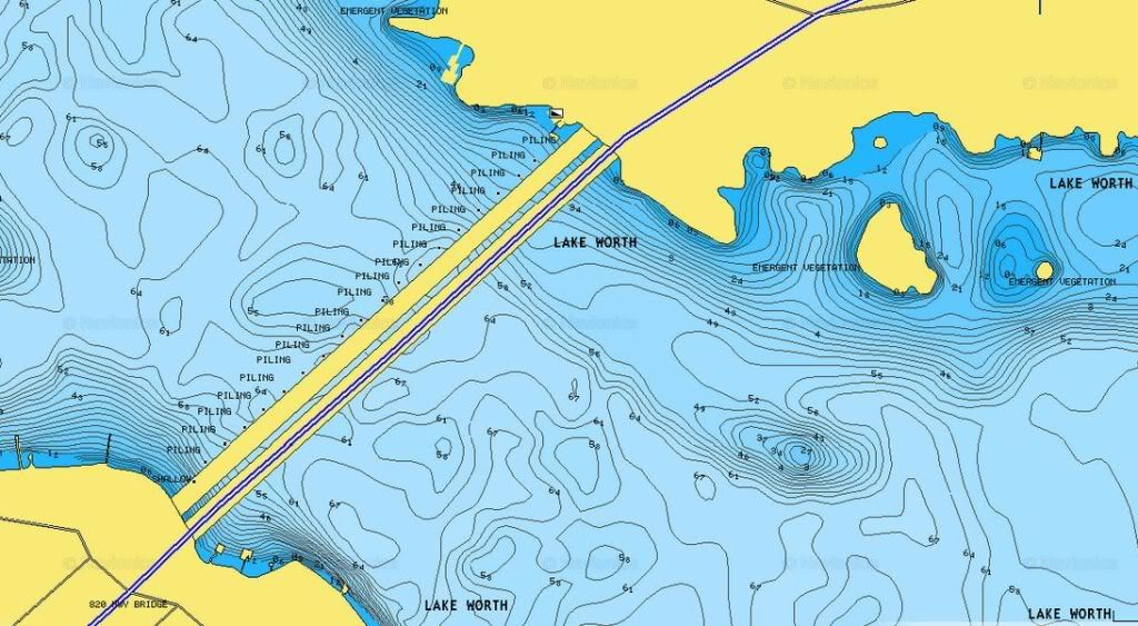 This was at Twak a while back, doing alittle catfishing. I don't have a FF so I keep my phone kind of handy with this app up. When I had my bass boat I checked to see how close it's on, and decided it's all I needed. NOtice how steep these humps are. 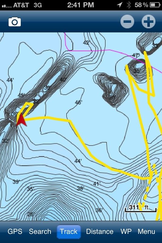 When you get serious, you can start layering old maps over newer ones. Take these... Notice the difference?  
|
|
|
Re: Learning to use a topo map
[Re: Kayak_and_Crossbones]
#8593233
02/15/13 05:40 AM
|
Joined: Jun 2005
Posts: 2,671
Bass fro chop
Extreme Angler
|
|
Extreme Angler
Joined: Jun 2005
Posts: 2,671 |
good depth map of lakes. zoom in your lake. doesnt work on smaller lakes http://viewer.flytomap.com/i fish for sandbass and hybrids mainly. humps where water goes from 30 foot to 15 back to 30 etc are great spots usually
Last edited by Bass fro chop; 02/15/13 05:41 AM.
|
|
|
Re: Learning to use a topo map
[Re: Kayak_and_Crossbones]
#8593242
02/15/13 05:46 AM
|
Joined: Jun 2005
Posts: 2,671
Bass fro chop
Extreme Angler
|
|
Extreme Angler
Joined: Jun 2005
Posts: 2,671 |
also you can get a fishing hot spots maps from bass pro for about 10 dollars of your favorite lake
|
|
|
Re: Learning to use a topo map
[Re: Kayak_and_Crossbones]
#8594001
02/15/13 03:19 PM
|
Joined: Nov 2011
Posts: 68
jake100
Outdoorsman
|
|
Outdoorsman
Joined: Nov 2011
Posts: 68 |
way cool that flymap link thanx
|
|
|
Re: Learning to use a topo map
[Re: Kayak_and_Crossbones]
#8594091
02/15/13 03:40 PM
|
Joined: Jul 2008
Posts: 2,469
gutcheck
Extreme Angler
|
|
Extreme Angler
Joined: Jul 2008
Posts: 2,469 |
Marine Creek is a small lake and it's not on most map chips. It's not in navionics. The good news is since its small its not hard to get a feel for where there's deep near shallow stuff if you have a FF. That's what I'm looking for 90% of the time: deep near shallow. But you sometimes have to just figure it all out yourself. I live near White Rock and its a very similar deal: no maps. But it's no surprise that since the deepest water is near the dam, that's also where you find the most dramatic drop offs and its where the fishing is consistently the best for me. There are times when fishing in the upper end near the river/creek is what you want too though. Just trial and error. Part of the fun IMO is figuring it all out. Soon the spawn will fire up and you'll want to be up in the shallow sheltered areas where they're bedding, but that doesn't last long...
|
|
|
Re: Learning to use a topo map
[Re: gutcheck]
#8594501
02/15/13 05:00 PM
|
Joined: Sep 2012
Posts: 1,332
Kayak_and_Crossbones
OP
Extreme Angler
|
|
OP
Extreme Angler
Joined: Sep 2012
Posts: 1,332 |
So much good info here I don't even know where to start. NoconaBain: Two questions. 1. Whats the name of that app? Can't keep a fishing weapon like that a secret.  2. How would I know that the humps in that photo are not depressions? Bass Fro chop...great link! Thanks! And I'll definitely be checking into the "hot spots" from bass pro. Gutcheck: The "deep near shallow" is exactly the kind of info I'm looking for. I'm sure for many on here its a no brainer...I'm still learning the basics on working a lake. 
|
|
|
Re: Learning to use a topo map
[Re: Kayak_and_Crossbones]
#8595459
02/15/13 08:42 PM
|
Joined: Jun 2005
Posts: 23,930
Nocona Brian
TFF Guru
|
|
TFF Guru
Joined: Jun 2005
Posts: 23,930 |
The app is navionics, it's in itunes.
When you see those numbers, on the map, their telling you how deep it is, so say on most of those humps in the screenshot, the tops are around 30' foot deep, then notice the next numbers on the bottom of the lake are around 45'. From that you can tell whether or not its a hump. If it was a hole, it'd have something deeper than 45' in the center. Also, don't consider those numbers accurate depths for whatever lake. Lakes fluctuate so more than likely, your FF will say it's a different depth. Use them as references, because as that, they are accurate.
|
|
|
Re: Learning to use a topo map
[Re: Kayak_and_Crossbones]
#8595826
02/15/13 10:09 PM
|
Joined: Jan 2005
Posts: 3,810
gotreal formerly known as getreal
TFF Team Angler
|
|
TFF Team Angler
Joined: Jan 2005
Posts: 3,810 |
is that map in meters wafflesjaw?
yup   if ye aint been skunked, ye aint been fishing! <<al einstene IAMCOUNTRY texas made lures. getcha some 
|
|
Moderated by banker-always fishing, chickenman, Derek 🐝, Duck_Hunter, Fish Killer, J-2, Jacob, Jons3825, JustWingem, Nocona Brian, Toon-Troller, Uncle Zeek, Weekender1
|


![[Linked Image]](http://i40.photobucket.com/albums/e226/gutcheck71/Mobile%20Uploads/Photo06071919.jpg)
![[Linked Image]](http://i40.photobucket.com/albums/e226/gutcheck71/null_zps67abec39.jpg)
![[Linked Image]](http://i40.photobucket.com/albums/e226/gutcheck71/Texomajuly007-1.jpg)
