|
Forums59
Topics1,052,867
Posts14,206,524
Members144,502
| |
Most Online39,925
Dec 30th, 2023
|
|
 Re: GPS Mapping Comparisons: LakeMaster, Navionics, Insight etc
[Re: Doug Vahrenberg]
#8009481
09/18/12 06:45 PM Re: GPS Mapping Comparisons: LakeMaster, Navionics, Insight etc
[Re: Doug Vahrenberg]
#8009481
09/18/12 06:45 PM
|
Joined: Sep 2012
Posts: 116
Pmnav12

Outdoorsman
|

Outdoorsman
Joined: Sep 2012
Posts: 116 |
Too funny... Doug gets all bent out of shape over the truth. okay thats why you explained to the area rep you were leaving for a better offer. Good for you if you found a better deal but dont play so innocent as to thats not why you are on here. See right through it. Good loyalty. Actions speak for themselves. I'll move on but we both know it wasnt becausee you simply "wanted to". So let people see that and believe what they want.
I'm shocked this forum lets you make it a marketing site instead of informational, fishing reports, and simple product awarness instead of your advertising. I can gladly hand pick screenshots as well and make a one sided approach without proof the other isnt correct. in fact, why dont i post one up tomorrow showing how the data we use on underwater IS correct. i have a saved shots of that... ill do that shortly.
Curious on "new" your data is? did you get a chopper with sonar to fly over the lake trees and do a recording? thats the only way in the last three years. Yup, the data you "randomly" selected has no charting there because there are TREES there. seems like this is the old free data from many many moons ago and much of the old Hot Spots data. Hey you gotta start with something but at least we have 50 states instead of what? 9? number of lakes above dont lie.
oh and $99 for one state with a handful of lakes vs $149 for multiple states with probably 50X the number of lakes? and ours doesnt run out unless you want to run into a tree? at least we put up what we know is or is not there not guess or use old stuff. But dont worry, we will add more data soon as we update daily.
oh Triton Mike... how about Carters? Sinclair? Oconee? Clarks Hill? oh i see only picked the 3 lakes you have. pretty funny. oh and thats why one of your guys was on facebook talking about how they needed to resound Lanier and had a boat to correct it because the mapping was wrong. oh wait, maybe it found a second "tree". really? a tree? anyone knowing charting will find that hilarious. One tree on a chart... please. That would be a good sonar that would find that which Humminbird has but it wouldnt be on a chart as ONE tree.
so okay I'm game. Now I just need to research what lakes Lakemaster actually has. Lets pick a Texas Lake, say lake fork. A florida lake... maybe Kissimeee? Toho? For Ga, you pick it. Additonally why dont we see how long it takes either company to correct a mistake if one is found and not only post screenshots of each map but sonar shot with it for verification with lat/long. PLUS a follow up on corrections and how much it cost to get that correction? you both good with that?
|
|
 Re: GPS Mapping Comparisons: LakeMaster, Navionics, Insight etc
[Re: Doug Vahrenberg]
#8009594
09/18/12 07:08 PM Re: GPS Mapping Comparisons: LakeMaster, Navionics, Insight etc
[Re: Doug Vahrenberg]
#8009594
09/18/12 07:08 PM
|
Joined: Sep 2012
Posts: 116
Pmnav12

Outdoorsman
|

Outdoorsman
Joined: Sep 2012
Posts: 116 |
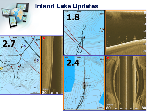 just a quick one from a recent trip out.We have verified these spots exist. and no its not a single tree. thats a FAD.
Last edited by Pmnav12; 09/18/12 07:11 PM.
|
|
 Re: GPS Mapping Comparisons: LakeMaster, Navionics, Insight etc
[Re: Doug Vahrenberg]
#8009739
09/18/12 07:42 PM Re: GPS Mapping Comparisons: LakeMaster, Navionics, Insight etc
[Re: Doug Vahrenberg]
#8009739
09/18/12 07:42 PM
|
Joined: Sep 2006
Posts: 2,975
Doug Vahrenberg
 OP
OP
Extreme Angler
|
OP

Extreme Angler
Joined: Sep 2006
Posts: 2,975 |
I'm not bent out of shape. Never told anyone it was a better deal and it wasn't financial for sure...I just get the product I need annually and return for new product each year in return for what I do for them. I worked my but off trying to help Navioncis on Truman Lake and to date that data has never been added. Lack of coverage on Truman is one of the biggest reasons I left and it is still today. Ask Jeff Broduer, Shaun Ruge, or Rochelle...I sent them an email back in 2010 when I made the decision after testing the LakeMaster Product. It was a very hard decision, I had some great friendships with Navionics but to me it's about the product. When you advertise coverage you should get coverage for the entire lake. Funny thing is only one person ever responded to my leaving letter that was Jeff Broduer which I still consider a very good friend...we still converse alot on Facebook. Here was the the work I was doing for Navionics in July of 2010 and after updating my chart again last night was still not there. If you want proof look at my Facebook Page on July 18,2010 under Wall Photos it's still there and the conversation with consumers.  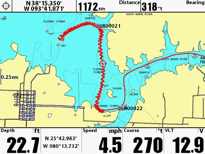 And for accuracy of LakeMaster this is one I did on Truman Lake...photo of the area, Humminbird Side Imaging and LakeMaster Maps...looks to me they scanned it right on...compared to the actual structure under the water. Same thing I find most everywhere I go. Want me to post a comparison of that spot? 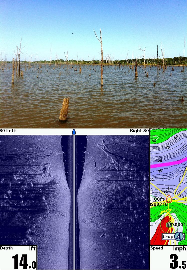 FYI - Sold Navioncis another map card last night to a guy from Arlington, Texas that called because of where he fishes. Because Navionics had the coverage for him today for his Humminbird. As for Chart Date lets compare. Paul and Mike you are employees of the Navionics and I'm just a prostaffer but would be happy to share screen captures of the Mapping Details. And if you have InSight or any other brand maps that have the same area of coverage let's let the consumers see the differences. It's not about your girl friend is pretty than mine...it's about what every company has to offer for the consumer spending his hard earned money and getting the most for his mapping needs.
 Website: www.dougvahrenberg.comSponsored by: Skeeter, Yamaha, MinnKota, Humminbird, LakeMaster, Transducer Shield & Saver, LuckyCraft, Dobyns Rods, Daiwa, Dave's Custom Baits, Omega Custom Tackle, Browning Eyewear, Elite Tungsten Co., Angler Innovations, Massey Ferguson.
|
|
 Re: GPS Mapping Comparisons: LakeMaster, Navionics, Insight etc
[Re: Doug Vahrenberg]
#8010099
09/18/12 09:17 PM Re: GPS Mapping Comparisons: LakeMaster, Navionics, Insight etc
[Re: Doug Vahrenberg]
#8010099
09/18/12 09:17 PM
|
Joined: Sep 2012
Posts: 116
Pmnav12

Outdoorsman
|

Outdoorsman
Joined: Sep 2012
Posts: 116 |
Doug, Screenshot of trees is a great image of Humminbird. I have ZERO issue with that. Great plotter! So that screenshot is good but map doesnt show the trees. See the navionics chart where there is green coloration? That is where the trees are so yes, we marked that quite well. I dont see that on the Lakemaster chart indicating trees in that area? Unless I'm missing it? That would be helpful for fishing and safe navigation. also, I didnt have the ability to work with you back in 2010 but appreciate the efforts done either way. i will ask about the tracks you did. in fact, if we do launch them, i could name them on the Navionics map for you as Doug's area?  didnt hear an answer back on my offer of the little charting challenge though? assuming thats a no on those answers. and i agree it is defintiely about what works best for the consumer. For that I agree with you absolutely!! it just needs to be fair and accurate. thats where i jumped in. Otherwise, I am also happy to discuss any charting company or discussion good or bad. That why Navionics is doing so many changes to the charts on a daily basis to constantly improve and also offer mobile apps to allow people to play with the joy of fishing/boating anywhere. good stuff
|
|
 Re: GPS Mapping Comparisons: LakeMaster, Navionics, Insight etc
[Re: Doug Vahrenberg]
#8010385
09/18/12 10:28 PM Re: GPS Mapping Comparisons: LakeMaster, Navionics, Insight etc
[Re: Doug Vahrenberg]
#8010385
09/18/12 10:28 PM
|
Joined: Sep 2006
Posts: 2,975
Doug Vahrenberg
 OP
OP
Extreme Angler
|
OP

Extreme Angler
Joined: Sep 2006
Posts: 2,975 |
Oops I had a miss spelling in the last sentence. It should be lets Compare Chart Data (Not Date). Go first, pick a lake that we both have coverages and we will compare. I have cards for Alabama, Georgia, Florida; Great Plains and Texas is all I get on my prostaff deal. Here is the where you can get Lake List Data: http://www.lakemap.com/humminbirddigitalgpsfishingmapcards.aspxJust click on the card to find the lake lists and we will compare. You choose a lake and couple screen shots and then I'll choose a lake and a couple screen shots. If you don't the like the areas I choosed pick a couple more. This is what I was hoping your Sales Manager Mike Dixon was going to do when he and I discussed comparing data from the lakes. We started by comparing HD Lakes to HD Lakes but I'm Open. Since this forum is mainly Texas Fisherman we were discussing the lakes in their interest but I'm open to any lake anywhere I can help show examples. --- I can see the trees physically it's nice you have them listed...but what I need is the depth and structure these trees are located in. This is what makes the difference in catching and patterning fish in flooded forests...it's not the trees but where the trees are located that helps you catch fish on Truman Lake. I found this area on my Home Waters this year that I have fished since the late 80's earlier 90's and never knew this point extended this far out and the depths of the trees was critical to catch 5 keepers on 10 casts. Using Lake Master Shallow Water Highlight and Depth Highlight allowed me to find this new honey hole for me. I would rather have contours to make fishing decision and navigate. Especially when the options is zero data.  This image shows where the data has ceased since Truman Lake was scanned in Fall 2006? or 2007? I was duck hunting when they scanned near Bucksaw cause the ice was on and the ducks piled in and the open water. That's why the data ended where it did...ice. Also use to have a void where we duck hunted but that's filled in now. Harry S Truman Reservoir is advertised as scanned in HD Details of 1 foot contours too. Didn't want to bring this up but you asked if you would rather have trees labelled or not. Guess I would like to have data versus none since I bet 90% of the boats that launch at Bucksaw the largest marina on Truman head up river. LakeMaster covers past MO13 here. Here's example of LakeMaster Coverage of that area...please disregard my waypoints...I'm the only one that catches fish here  Navionics  LakeMaster 
Last edited by Doug Vahrenberg; 09/18/12 10:29 PM.
 Website: www.dougvahrenberg.comSponsored by: Skeeter, Yamaha, MinnKota, Humminbird, LakeMaster, Transducer Shield & Saver, LuckyCraft, Dobyns Rods, Daiwa, Dave's Custom Baits, Omega Custom Tackle, Browning Eyewear, Elite Tungsten Co., Angler Innovations, Massey Ferguson.
|
|
 Re: GPS Mapping Comparisons: LakeMaster, Navionics, Insight etc
[Re: Doug Vahrenberg]
#8012588
09/19/12 01:43 PM Re: GPS Mapping Comparisons: LakeMaster, Navionics, Insight etc
[Re: Doug Vahrenberg]
#8012588
09/19/12 01:43 PM
|
Joined: Sep 2012
Posts: 116
Pmnav12

Outdoorsman
|

Outdoorsman
Joined: Sep 2012
Posts: 116 |
So.... what youre saying is, safety isnt a concern? you are okay running and not knowing where trees, stumps, channels, etc are? I hope you have really good insurance. Not to mention if you have never been to a lake before, how would you know where trees are ahead of time. Using Lakemaster you wouldn't. No ability to preplan or look at a chart ahead of time. Isnt that what we all want to do rather than look at a chart go steaming towards that area and SLAM theres a bunch of trees I just hit in the dark OR if its daytime, my time and plan is now changed or wasted because there are trees there where i thought there werent? valuable piece of info you are missing. Again, please enlighten me on how to get the chopper with the sonar mounted on it to fly over the trees or is it that same old data we dropped from when the lake was first filled how many years ago?
Ah yes that one missing area.. okay fine. we have a missing area. That area we had as well from Fishing Hot spots for the time. We dropped it because we can do better on our own. We found a lot of info on those charts that were no longer correct. That info you have was done when the lake was being filled. Thats how many years ago? A lot more than 5. We will have that updated shortly for FREE to everyone on an update. Dont worry and it'll be very recent vs the hot maps data from 50? 70 years ago?
oh and if you want to compare empty spots.... should I post these spots up Lakemaster doesnt have? be happy to for reference? we have a couple missed spots that WE will fix.Meanwhile Lakemaster has missing lakes all over and is too worried about finding free data (not personally surveying!)in other parts of the Country to expand with more old data and forgetting Texas and moving on. JO bought Lakemaster so they have to do something. Free data and sell it for $99. Great deal for Lakemaster. Not so great for the consumer. oh heres your missing lakes again. $99 for two states and missing all the below. I'd be pissed.
This is what Navionics has in 1' contours in additon to the above that Lakemaster does not have: Arrowhead, Athens, Austin, Bob Sandlin, Brideport, Cedar Creek, Choke Canyon, Coleman, Coletto, Cooper, Corpus Christine, Crook, Cypress Springs, Eagle Mtn, Fairfield, Falcon, Graham, Granger, Greenbelt, Hawkins, Holbrook, Houston, Hubbard, Inks, JB thomas, Joe Pool, Kemp, Kickapoo, Limestone, Livingston, Marble falls, Martin, Medina, Meredith, Millers, Monticello, Muravi, Nacogoches, Navarro Mills, Nacona, OH Ive, Pat Celburne, Pat Mayse, Possum Kingdom, Proctor, Stamford, Stillhouse, Striker, Toledo Bend, Tradinghouse, Travis, Twin Buttes, Tyler, Waco, Weatheford, Welsh, Whitney, Worth, Wright Patman... also added this year in Frehsest data: Annahuac, Spring, Aquilla, Benbrook, Bonham, Cherokee, Galveston, Georgetown, Gladewater, Gudelupe, Halbert, Moss, Jacksonville, Kurth, Town, Lake o pines, leon river, Mexia, new terrel city, Palo pinto, Sabine, Keith, Squaw, Texana, Waxahachie, white river, White rock, Brazos, Rio Grande, San Benard, Mission.
Navionics has aside from 1' contours and lakemaster doesnt: Amon, BA Steigen, Barber, Bastrop, Bivens, Boerne, Brownwood, Buffalo, Cado, Cataharine, Ciscoe, Clyde, Colorado City, Davis, Dunlap, EV Spense, Eddleson, Electra, Ellison, Fayette, Fort Phantom hill, Georgetown, Gonzalez, Laguna Madre, McQueeny, Meadow, Mill Creek, Moss, Naworthy, New Terrel City, North Fork, OC fishcer, Oak Creek, Sabine, Sabine River, Spring, Sulpher Spring, Town, Tule Creek, Tyler, Victor Braunig, Walter E Long, Wood, Tarrant, Titus, Parker, Mclennan, Bexar, Smtih, Tom reen, Brisco, Hopkins, Rusk, Bell, Burleson, Haskell, Comanche, Lamar, Johnson, Coke, Wiuchita, Montague, Panola, Baylor, Anderson, Guadelupe, Bernett, Archer, Scurry, Donley, Young, Grimes, Frestone, Morris, Delta, Mitchell, Goliad, Coleman, Eatland, Brown, Bastrop, Ellis, Jasper, Clay, Henderson, Tarrant, Jones, Stephenson, Williams, Bowie, Jack wise, Hood, Matagorda, Concho, Titus, San Jaquinto, Kaufamn, Hunt, Garza, llano, Val Verde
As far as the offer... seems you wanted to modify. Here is my offer again and Mike and I are all over it...
"Lets pick a Texas Lake, say lake fork. A florida lake... maybe Kissimeee? Toho? For Ga, you pick it. Additonally why dont we see how long it takes either company to correct a mistake if one is found and not only post screenshots of each map but sonar shot with it for verification with lat/long. PLUS a follow up on corrections and how much it cost to get that correction? you good with that?"
|
|
 Re: GPS Mapping Comparisons: LakeMaster, Navionics, Insight etc
[Re: Dale Logue]
#8012968
09/19/12 03:09 PM Re: GPS Mapping Comparisons: LakeMaster, Navionics, Insight etc
[Re: Dale Logue]
#8012968
09/19/12 03:09 PM
|
Joined: Sep 2006
Posts: 2,975
Doug Vahrenberg
 OP
OP
Extreme Angler
|
OP

Extreme Angler
Joined: Sep 2006
Posts: 2,975 |
I NEVER Solely rely on GPS Maps for Navigation. They are an aid. Just like the Opening Screen says....  If you don't know where you are going you should not run on plane. If your running on plane you better be assured you know what's under the surface and know where you are going in todays modern bass boats that travel at 70mph or every second you travel over 102 Feet. Plus the accuracy of GPS is advertised by most manufacturers at 3 Meters. Are You and Your Company going to Guarnatee that if I run Navionics Maps that they are truly dead accurate to Navigation with? So you assume the Liability??? Hi Pmnav12,
Today, how many boats does Navionics own for surveying? Just curious.
Thanks,
Paul you haven't answered Mr' Logue's Question either. I know one thing the data I have used from LakeMaster is Spot on! And 99% of the lakes are covered from the bank to the channels. And when they advertise coverage...it's pretty much the whole lake...not less than half in some cases I've seen with other products. Here is the Advertised Lake List for Texas for LakeMaster. Black Highlighted Lakes are HD Lakes. Lets do what this thread was intended for Comparing Data from all GPS Mapping Companies for Texas Waters - I'm not against comparing other lakes in other regions just don't think Texas Fishing Forum members are interested in that data but if you want to go to forum in that region or a Nationwide forum we can. Want to do it on Bass Boat Central? I'm game. It all about showing what the consumer gets when he spends his hard earned money on mapping products. So lets show the Texans what they get on lakes both brands have coverage that is what consumers are asking for and agreement between me and your Southeast Sales Manager Mike Dixon. This is no different then Navionics Marketing Comparison that have been posted here. So lets give the users what they want to see. Comparison of the lakes they fish. That's all I've tried to do is show comparisons of areas of each lake that all the companies have advertised as having coverage for. Like I've been saying go first, Post your images from a Texas Lake from Navionics and I'll post LakeMaster Coverage of the same exact spot and zoom range. Then I'll go first and you post your comparison images. Nice if they come from the same brand unit for comparisons but 10" Humminbird or Lowrance shouldn't make a that much difference. Just trying to keep it as close to apple-to-apples so the consumer can decide what is best for them. This is the most current coverage Version 2 Of Texas/Oklahoma 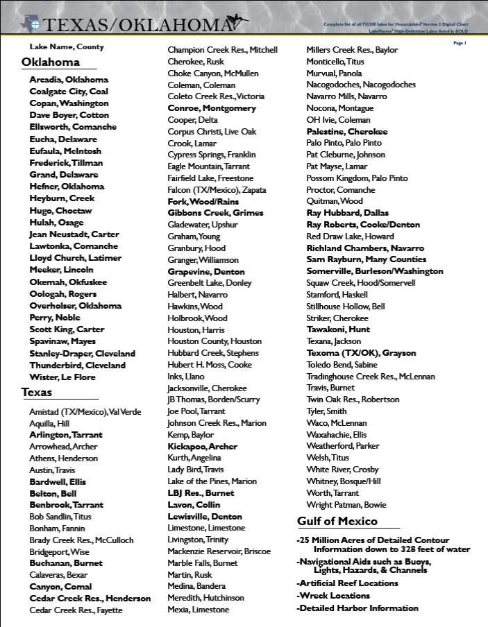 
 Website: www.dougvahrenberg.comSponsored by: Skeeter, Yamaha, MinnKota, Humminbird, LakeMaster, Transducer Shield & Saver, LuckyCraft, Dobyns Rods, Daiwa, Dave's Custom Baits, Omega Custom Tackle, Browning Eyewear, Elite Tungsten Co., Angler Innovations, Massey Ferguson.
|
|
 Re: GPS Mapping Comparisons: LakeMaster, Navionics, Insight etc
[Re: Doug Vahrenberg]
#8014653
09/19/12 11:02 PM Re: GPS Mapping Comparisons: LakeMaster, Navionics, Insight etc
[Re: Doug Vahrenberg]
#8014653
09/19/12 11:02 PM
|
Joined: Sep 2012
Posts: 116
Pmnav12

Outdoorsman
|

Outdoorsman
Joined: Sep 2012
Posts: 116 |
So, you're okay with keeping your chart unsafe by not adding tree lines? Good for people to know. Planning purposes, nope cant do that because there are no trees showing (well except for Mike's one tree in GA apparently). so we dont keep this part going in circles, anyone reading this, be aware, Lakemaster is not concerned about your safety or preplanning. Be sure to boat with extra person who has night vision and not run on full plane without radar or a buddy for guidance. if not, buy navionics. you may also want to consider this map, they didnt have much detail either 
|
|
 Re: GPS Mapping Comparisons: LakeMaster, Navionics, Insight etc
[Re: Doug Vahrenberg]
#8014697
09/19/12 11:17 PM Re: GPS Mapping Comparisons: LakeMaster, Navionics, Insight etc
[Re: Doug Vahrenberg]
#8014697
09/19/12 11:17 PM
|
Joined: Sep 2012
Posts: 116
Pmnav12

Outdoorsman
|

Outdoorsman
Joined: Sep 2012
Posts: 116 |
Intentionally not answering Dale's question. We dont have the "old school" survey boats but still have plenty. Not sharing that info. You going to tell me how many survey boats you have? last i knew it was four but not sure if they came with the deal.
of course its the whole lake. buying old data. So telling me you have four boats that surveyed all the lakes you mention above in 6 months for GA and Florida and one year in Texas. I dont think people are that stupid. you bought old data and fishing hot spots data. As pro staff I wouldnt expect you to know those details. again we dropped hot spots for old data that was no longer valid. the areas that show blank, was from them when we used to work with them. Again, we will have it FREE to users to upload soon enough rather than post old data.
okay so we will say that Navionics simply wins on total lake count and total HD lakes. Although I think that was shown clearly already. 256 Navionics. 82 Lakemaster. Hi Def Navionics 138... Lakemaster 33. Really is no argument to be had. people want value. we give it.
And youre still ducking my question. I'll help you.
You cant agree to my offer. Lakemaster has no way of updating charts with data except once a year. then you have to go and buy a whole new one for full retail. Navionics gives a year of free updates daily and adds lakes all year plus Commuity Edits and coming soon the new Sonar Chart. after a year, $99 and get another year free. Lakemaster.. shell out another $129 (sorry i thought you were $99) for "new" lakes. 35 this year which we both know didnt have survey boats. Plus if there is an error or empty space, as we get the data we release it that day for free. So those areas that you point out, yup we dont have recent data, but we will, and we will release it free when we do. Lakemaster... NOPE.
so no problem. I gave you my lake which is Fork. I also suggested to pick one in GA since Mike decided to chime in. Plus lets do Kissimmee or Toho in Florida. heck I'll even do two lakes in Texas if you like. Charts shots, sonar shots, and how quickly its updated or corrected if there is an error.I'll order a lakemaster chart today so we can play. Give me some time for that to arrive and our sales meeting next week. Dont want you to think I'm ignoring you.
|
|
 Re: GPS Mapping Comparisons: LakeMaster, Navionics, Insight etc
[Re: Doug Vahrenberg]
#8014724
09/19/12 11:26 PM Re: GPS Mapping Comparisons: LakeMaster, Navionics, Insight etc
[Re: Doug Vahrenberg]
#8014724
09/19/12 11:26 PM
|
Joined: Sep 2012
Posts: 116
Pmnav12

Outdoorsman
|

Outdoorsman
Joined: Sep 2012
Posts: 116 |
Quick reference Guide:
Navionics Texas lakes: 256 Lakemaster: 82
Navionics Hi Def 1' - 138 Lakemaster 33
Survey boats having been in Texas by Navionics : Yes
Survey boats having been in Texas by Lakemaster: none
Chart updates Navionics: yes
Chart updates Lakemaster: no
Chart updates how often Navionics: Daily
Chart Updates how often Lakemaster: none
Cost yearly when updates run out Navionics: $99
Cost yearly when updates run out Lakemaster: buy new chart end yr
Channel and tree shading Navionics: yes
Channel and tree shading Lakemaster: no
Shading of contours Navionics: yes
Shading of contours lakemaster: yes
adjustable contour shading Navionics: no
Adjustable contour shading Lakemaster: yes
underwater structures renewed and verifed Navionics: yes
" " " " " Lakemaster: no
creeks and channels and roadbeds Navionics: yes
creeks and channels and roadbeds Lakemaster: i dont know honestly
Realtime community edits Navionics: Yes
Realtime community edits Lakemaster: no
Ability to correct charts errors or missing data Navionics: yes
Ability to correct chart errors or missing data Lakemaster: no
Coastline correction Navionics: yes. Done this year for accuracy
Coastline correctiuo Lakemaster: no
NOAA coastline corrections: not in 50-70 years (Lakemaster base map)
Chart cost Navionics and get 12 states at $149
Chart cost Lakemaster and get 2 states at $129
okay time for dinner. figured easier to read than us back and forth this way
|
|
 Re: GPS Mapping Comparisons: LakeMaster, Navionics, Insight etc
[Re: Doug Vahrenberg]
#8014726
09/19/12 11:26 PM Re: GPS Mapping Comparisons: LakeMaster, Navionics, Insight etc
[Re: Doug Vahrenberg]
#8014726
09/19/12 11:26 PM
|
Joined: Sep 2012
Posts: 116
Pmnav12

Outdoorsman
|

Outdoorsman
Joined: Sep 2012
Posts: 116 |
post more differences later...
|
|
 Re: GPS Mapping Comparisons: LakeMaster, Navionics, Insight etc
[Re: Doug Vahrenberg]
#8014836
09/20/12 12:00 AM Re: GPS Mapping Comparisons: LakeMaster, Navionics, Insight etc
[Re: Doug Vahrenberg]
#8014836
09/20/12 12:00 AM
|
Joined: Oct 2011
Posts: 681
Diel11

Pro Angler
|

Pro Angler
Joined: Oct 2011
Posts: 681 |
I'm in the market right now for a chip. Sounds like Navionics is the way to go but the only thing that has stopped me so far is this thread.
Why is it that the Navionics man is trying to belittle everything instead of just showing facts like he said? We are not dumb, just like he said. But if you come in here with the attitude of a child that has never had any power over anyone or anything, then gets a bit and goes crazy, it sure is a turn off. I am both Lakemaster's and Navionic's target customer. I didn't know anything about the whole old data vs. helicopter scanning, etc. That was really good information, but was presented in such a rude and cocky way it made it secondary to the attitude. If it was just said and then left alone, with no other unnecessary comments, that alone would win it for me.
I understand being passionate about a product or company, but I tell you, if you present the information without any cockiness or attitude, it will go way further. The inside information is great, most of us might not know how these chips and information are put together. So please, without the attitude, help us out with more awesome information so we can become customers of Navionics if we want to, Lakemaster if we don't.
With respect, have a good night.
|
|
 Re: GPS Mapping Comparisons: LakeMaster, Navionics, Insight etc
[Re: Doug Vahrenberg]
#8015244
09/20/12 01:52 AM Re: GPS Mapping Comparisons: LakeMaster, Navionics, Insight etc
[Re: Doug Vahrenberg]
#8015244
09/20/12 01:52 AM
|
Joined: Sep 2006
Posts: 2,975
Doug Vahrenberg
 OP
OP
Extreme Angler
|
OP

Extreme Angler
Joined: Sep 2006
Posts: 2,975 |
Diell11 which lakes would you like to see data from. That's why I started this post is for people like you that wants to see data. I have no problem getting you data. I have the most current product from both companies and if you wish to share Lat/Lon or areas you want scanned I'll post images so you the customer can see the data that is offer.
Yes, I'm just a Prostaff Member of LakeMaster and Humminbird. I own both mapping products and willing to share to help you make the best decision for you. I'm not the Navionics National Sales Manager (Paul Michele) or Navionics South East Regional Sales Manager (Mike Dixon) that seems more concerned with not sharing their Mapping Data but to take attacks at LakeMaster and make false statements about me. I don't know how LakeMaster does their mapping but it's not a helicopter. I can verify the places I have used their data it's been very, very accurate to what is under the water. I can verify that in most cases the lakes you purchase have 90%+ of the lakes water has contours. I'm here to show "Proof" with images from the areas you want to see data.
Just let me know the areas or lakes you want to see and I will post them for you.
 Website: www.dougvahrenberg.comSponsored by: Skeeter, Yamaha, MinnKota, Humminbird, LakeMaster, Transducer Shield & Saver, LuckyCraft, Dobyns Rods, Daiwa, Dave's Custom Baits, Omega Custom Tackle, Browning Eyewear, Elite Tungsten Co., Angler Innovations, Massey Ferguson.
|
|
 Re: GPS Mapping Comparisons: LakeMaster, Navionics, Insight etc
[Re: Doug Vahrenberg]
#8015366
09/20/12 02:20 AM Re: GPS Mapping Comparisons: LakeMaster, Navionics, Insight etc
[Re: Doug Vahrenberg]
#8015366
09/20/12 02:20 AM
|
Joined: Oct 2011
Posts: 681
Diel11

Pro Angler
|

Pro Angler
Joined: Oct 2011
Posts: 681 |
Let's see Tawakoni, Texoma and Ray Hubbard please. Tawakoni has the Sherwood Forest and it would be nice to know how it's laid out. Talk about a problem for a first timer when you are flying into the middle of the lake and all of a sudden there's a freaking forest sticking out of the water!! I usually do what Doug said, if I don't know the lake, I don't plane. But I would like to see the underwater layout.
Thank you very much.
|
|
 Re: GPS Mapping Comparisons: LakeMaster, Navionics, Insight etc
[Re: Doug Vahrenberg]
#8015745
09/20/12 04:36 AM Re: GPS Mapping Comparisons: LakeMaster, Navionics, Insight etc
[Re: Doug Vahrenberg]
#8015745
09/20/12 04:36 AM
|
Joined: Sep 2006
Posts: 2,975
Doug Vahrenberg
 OP
OP
Extreme Angler
|
OP

Extreme Angler
Joined: Sep 2006
Posts: 2,975 |
Since we already did Lake Fork but you want to compare again here is more images from LakeMaster. I know the Big Bass Tournament is this weekend and reports are the fish are shallow and in the back of the creeks so lets start there. Ray Creek @ Zero Water Level Offset  Big Caney Creek @ Zero Water Level Offset  State Record Point @ Zero Water Level Offset  Board Tree Branch @ Zero Water Level Offset  Here's the Brood Pond in Board Tree Branch at Maximum Zoom Level @ Zero Water Level Offset  Hump above the 2946 Bridge @ Zero Water Level Offset  One of the Cool Exclusive Features of LakeMaster is the ability for the User to Adjust Water Level and Contour to the current lake level. Easy way is to match depth readings to your sonar readings for the days conditions. This is a big feature in Texas with the decent droughts and low water levels. Here is Water Level Adjusted -10 Foot to simulate low water levels or drought.  Another cool Exclusive Feature of LakeMaster is setting a Shallow Water Highlight (Red) kind of like Shaded Depth for Navionics. Makes finding the top of the humps real easy. But the Neat Feature that is Exclusive to LakeMaster is the Depth Highlight and Depth Highlight Range. For Example in this image if you wanted to throw a LuckyCraft Flat CB D-20 or Norman DD22 that dive to max depth of about 20 foot you can set the Depth Highlight to 18 and Range to 2 and it will shade + or - 2 Foot so 16 to 22 Foot is colored Green...now you know the Depth Range of your bait or structure to target to catch more fish.  Remove the Menu Box and you can find a few more places in that Depth Highlight Range  There you go some images from Lake Fork.
 Website: www.dougvahrenberg.comSponsored by: Skeeter, Yamaha, MinnKota, Humminbird, LakeMaster, Transducer Shield & Saver, LuckyCraft, Dobyns Rods, Daiwa, Dave's Custom Baits, Omega Custom Tackle, Browning Eyewear, Elite Tungsten Co., Angler Innovations, Massey Ferguson.
|
|
Moderated by banker-always fishing, chickenman, Derek 🐝, Duck_Hunter, Fish Killer, J-2, Jacob, Jons3825, JustWingem, Nocona Brian, Toon-Troller, Uncle Zeek, Weekender1
|

