|
Forums59
Topics1,055,082
Posts14,247,877
Members144,549
| |
Most Online39,925
Dec 30th, 2023
|
|
 Re: Lake Fork Map
[Re: Doug Vahrenberg]
#7828159
08/01/12 03:33 PM Re: Lake Fork Map
[Re: Doug Vahrenberg]
#7828159
08/01/12 03:33 PM
|
Joined: Nov 2010
Posts: 5,150
Wayne P.

TFF Celebrity
|
|
TFF Celebrity
Joined: Nov 2010
Posts: 5,150 |
Someone contacted me and asked about comparing mapping between Electronics and Mapping Company. Since this post got into some comparison the image below shows the comparison as equal as can be done between Electronics Manufacturers and Mapping Companies. Intersting the differences. 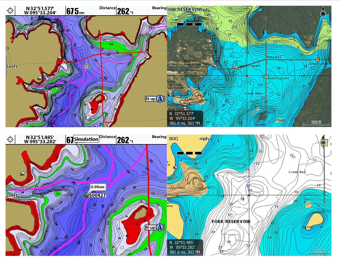 Which software has the true path of the creek channels? They are not the same and not even close in some areas.
Helix 12 CHIRP MEGA SI+ GPS G4N, SOLIX 10 G3, Helix 15 CHIRP MEGA SI+ GPS G4N,
Helix 8 CHIRP MEGA SI+ GPS G4N, SOLIX 12 G3, MEGA 360, MEGA LIVE TL , MEGA LIVE 2, Xplore 10
|
|
|
Re: Lake Fork Map
[Re: Kansas Basser]
#7829556
08/01/12 08:50 PM
|
Joined: Oct 2005
Posts: 981
Rob Jasper Lowrance Pro-Staff
Pro Angler
|
|
Pro Angler
Joined: Oct 2005
Posts: 981 |
Lake Master is pretty and colorfull for sure, but I see more benefit out of the Navionics mapping. The improvments they have made and ability to stay up to date are a tremendous. I found a hump just a few weeks ago that produced a fish with just minutes to go in a tournament. If it had not been for Navionics mapping that fish would have never gotten to my boat.
Rob Jasper
|
|
|
Re: Lake Fork Map
[Re: Kansas Basser]
#7831336
08/02/12 03:04 AM
|
Joined: Sep 2006
Posts: 2,975
Doug Vahrenberg
Extreme Angler
|
|
Extreme Angler
Joined: Sep 2006
Posts: 2,975 |
Those Pretty Colors make it easy to tell depth quickly without having to focus on depth numbers. Mapping should be easy to interpret...you want to spend your time focusing on reading a contour map or using the data to catch more fish??? Can you explain the differences? Circles are major differences and the arrows are the arrows show the "Sweet Spots" I look for that will hold fish on bigger structures. 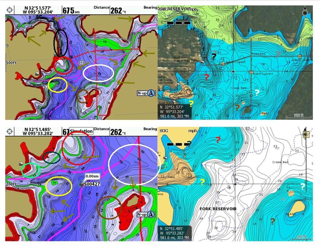 Speaking of Humps where is the one circled in Yellow? The Details are in the maps. Get what works best for you.
 Website: www.dougvahrenberg.comSponsored by: Skeeter, Yamaha, MinnKota, Humminbird, LakeMaster, Transducer Shield & Saver, LuckyCraft, Dobyns Rods, Daiwa, Dave's Custom Baits, Omega Custom Tackle, Browning Eyewear, Elite Tungsten Co., Angler Innovations, Massey Ferguson.
|
|
|
Re: Lake Fork Map
[Re: Kansas Basser]
#7831792
08/02/12 04:43 AM
|
Joined: May 2010
Posts: 4,584
lamoon78
TFF Team Angler
|
|
TFF Team Angler
Joined: May 2010
Posts: 4,584 |
I have noticed over the last week I spent everyday on Rayburn compareing the 2 cards and Lakemaster by far had the best detail and what you seen on the map is what you seen underwater not so much with Navionics I still use both cards for different reasons but of the two Lakemaster is way better IMHO.
|
|
|
Re: Lake Fork Map
[Re: Kansas Basser]
#7832332
08/02/12 01:20 PM
|
Joined: Sep 2006
Posts: 2,975
Doug Vahrenberg
Extreme Angler
|
|
Extreme Angler
Joined: Sep 2006
Posts: 2,975 |
Red Circled Detail - Point on a Point at 20 Foot Zoom Level  Yellow Circle - Hump and Point Details at 50 Foot Zoom Level  Black Circle - Channel Swing Bank...Channel Does not reach the bank. Using Depth Hightlight I shaded from 21-23 Foot and you can make is show the channel much easier and how close the channel gets to the bank.  Brown Circle - Point and Ditch on Island at 50 foot Zoom Level  White Circle - Differences in Depth Readings and How this ditch is charted.
Website: www.dougvahrenberg.comSponsored by: Skeeter, Yamaha, MinnKota, Humminbird, LakeMaster, Transducer Shield & Saver, LuckyCraft, Dobyns Rods, Daiwa, Dave's Custom Baits, Omega Custom Tackle, Browning Eyewear, Elite Tungsten Co., Angler Innovations, Massey Ferguson.
|
|
|
Re: Lake Fork Map
[Re: Kansas Basser]
#7832356
08/02/12 01:27 PM
|
Joined: Sep 2006
Posts: 2,975
Doug Vahrenberg
Extreme Angler
|
|
Extreme Angler
Joined: Sep 2006
Posts: 2,975 |
Now lets look at some of the arrows Top Right of the Image first small bay in the Creek Contours of the Bay... 100 Foot Zoom Level  20 Foot Zoom Level  Let's look at the small ditech and points on the right bank  And the Road coming off the top side of the island  Now what happens when they pull more water out of the lake or we have a drought and the lake goes down???? Island at Full Pool  No the Lake is Down 5 Foot...you don't have to use your mind to subtract the depth of each contour or where is the bank or you the safety shading with Shallow Water Highlight or you Depth Highlight...just reduce the Water Level Offset by the Depth the Lake is lower or raised and it redraws the map to the new water level 
Website: www.dougvahrenberg.comSponsored by: Skeeter, Yamaha, MinnKota, Humminbird, LakeMaster, Transducer Shield & Saver, LuckyCraft, Dobyns Rods, Daiwa, Dave's Custom Baits, Omega Custom Tackle, Browning Eyewear, Elite Tungsten Co., Angler Innovations, Massey Ferguson.
|
|
|
Re: Lake Fork Map
[Re: Mike Dixon]
#7837158
08/03/12 04:03 PM
|
Joined: Jul 2012
Posts: 58
Mike Dixon
Outdoorsman
|
|
Outdoorsman
Joined: Jul 2012
Posts: 58 |
I will have too look again Doug on both cards for Livingston when I fished it a few weeks ago were I was at had no detail on either card course the average depth were I was at is probably only 5-7 feet so probably cant get much detail out of that. I'd make sure you're taking advantage of the Freshest Data updates for your Navionics card. Not sure when Livingston got all this detail, but it's most definitely there. It would be a shame to go fishing without it. A few more with some zooming for better idea of what's on there...   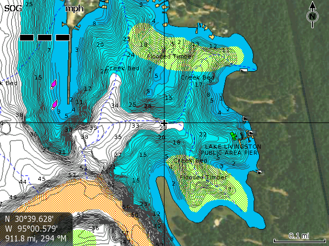 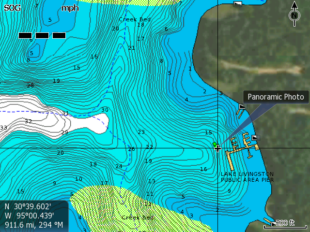 Anyone have any Lakemaster shots at this zoom for Livingston we can look at? Appreciate the comparatives, Doug. But even close to your "?" you post in the Navionics maps, there appears to be detail nearby that doesn't appear in the Lakemaster map. I think all can easily see that there are presentations in each map that are absent in the other. How often does Lakemaster update these maps, or do they remain static forever?
|
|
|
Re: Lake Fork Map
[Re: Kansas Basser]
#7839565
08/04/12 02:08 AM
|
Joined: Sep 2006
Posts: 2,975
Doug Vahrenberg
Extreme Angler
|
|
Extreme Angler
Joined: Sep 2006
Posts: 2,975 |
Already posted Livingston from LakeMaster. Livingston is not HD from LakeMaster yet. Like most all Mapping Companies LakeMaster Continually scans and adds new data as they acquire the data. Texas/Oklahoma is already on the second version where several lakes where added and many where updated to higher data levels. LakeMaster is only in it's second year of scanning Texas and Oklahoma lakes. Looks like they are capturing more details when they do get everything in HD.
Want to compare more HD Lakes? I'm Game...it only helps the consumer in choosing the best mapping products for them.
Website: www.dougvahrenberg.comSponsored by: Skeeter, Yamaha, MinnKota, Humminbird, LakeMaster, Transducer Shield & Saver, LuckyCraft, Dobyns Rods, Daiwa, Dave's Custom Baits, Omega Custom Tackle, Browning Eyewear, Elite Tungsten Co., Angler Innovations, Massey Ferguson.
|
|
|
Re: Lake Fork Map
[Re: Kansas Basser]
#7839610
08/04/12 02:18 AM
|
Joined: Sep 2006
Posts: 2,975
Doug Vahrenberg
Extreme Angler
|
|
Extreme Angler
Joined: Sep 2006
Posts: 2,975 |
Here's more HD Lakes from LakeMaster...want to compare? Texoma:   Ray Roberts:   Lewisville:  
Website: www.dougvahrenberg.comSponsored by: Skeeter, Yamaha, MinnKota, Humminbird, LakeMaster, Transducer Shield & Saver, LuckyCraft, Dobyns Rods, Daiwa, Dave's Custom Baits, Omega Custom Tackle, Browning Eyewear, Elite Tungsten Co., Angler Innovations, Massey Ferguson.
|
|
|
Re: Lake Fork Map
[Re: Kansas Basser]
#7839638
08/04/12 02:24 AM
|
Joined: Sep 2006
Posts: 2,975
Doug Vahrenberg
Extreme Angler
|
|
Extreme Angler
Joined: Sep 2006
Posts: 2,975 |
Website: www.dougvahrenberg.comSponsored by: Skeeter, Yamaha, MinnKota, Humminbird, LakeMaster, Transducer Shield & Saver, LuckyCraft, Dobyns Rods, Daiwa, Dave's Custom Baits, Omega Custom Tackle, Browning Eyewear, Elite Tungsten Co., Angler Innovations, Massey Ferguson.
|
|
|
Re: Lake Fork Map
[Re: Kansas Basser]
#7839666
08/04/12 02:32 AM
|
Joined: Sep 2006
Posts: 2,975
Doug Vahrenberg
Extreme Angler
|
|
Extreme Angler
Joined: Sep 2006
Posts: 2,975 |
Cedar Creek:   Tawakoni:   Palestine:   Sam Rayburh: Canyons  Farmers Flats  Now to be equal for comparison purposes we need to maintain the Zoom Level Scale and the same GPS Coordinates of the Cursor so we can try to get the best comparison we can between the brands.
Website: www.dougvahrenberg.comSponsored by: Skeeter, Yamaha, MinnKota, Humminbird, LakeMaster, Transducer Shield & Saver, LuckyCraft, Dobyns Rods, Daiwa, Dave's Custom Baits, Omega Custom Tackle, Browning Eyewear, Elite Tungsten Co., Angler Innovations, Massey Ferguson.
|
|
|
Re: Lake Fork Map
[Re: Kansas Basser]
#7839696
08/04/12 02:40 AM
|
Joined: Sep 2006
Posts: 2,975
Doug Vahrenberg
Extreme Angler
|
|
Extreme Angler
Joined: Sep 2006
Posts: 2,975 |
IF you have others you would like to compare here is the LakeMaster Lake List for Texas Oklahoma the BOLD listings are in HD Detail for 2012. 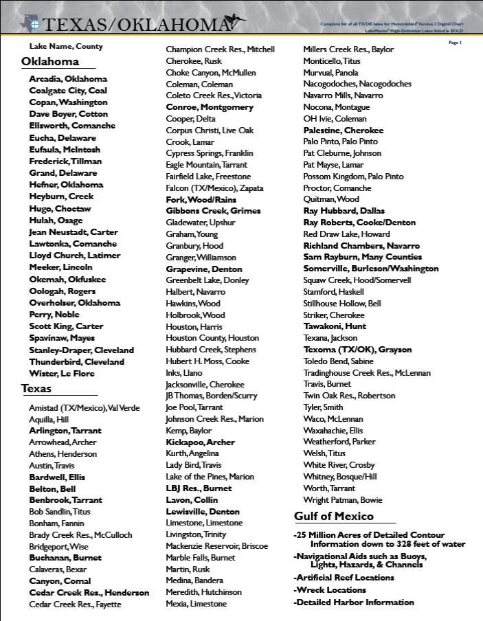  If anyone has requests for the details of any of the LakeMaster Listings and wants examples tell me approximate coordinates and I will get examples for you.
Last edited by Doug Vahrenberg; 08/04/12 02:42 AM.
Website: www.dougvahrenberg.comSponsored by: Skeeter, Yamaha, MinnKota, Humminbird, LakeMaster, Transducer Shield & Saver, LuckyCraft, Dobyns Rods, Daiwa, Dave's Custom Baits, Omega Custom Tackle, Browning Eyewear, Elite Tungsten Co., Angler Innovations, Massey Ferguson.
|
|
|
Re: Lake Fork Map
[Re: Doug Vahrenberg]
#7845928
08/06/12 12:52 PM
|
Joined: Jul 2012
Posts: 58
Mike Dixon
Outdoorsman
|
|
Outdoorsman
Joined: Jul 2012
Posts: 58 |
Already posted Livingston from LakeMaster. Livingston is not HD from LakeMaster yet. Like most all Mapping Companies LakeMaster Continually scans and adds new data as they acquire the data. Texas/Oklahoma is already on the second version where several lakes where added and many where updated to higher data levels. LakeMaster is only in it's second year of scanning Texas and Oklahoma lakes. Looks like they are capturing more details when they do get everything in HD.
Want to compare more HD Lakes? I'm Game...it only helps the consumer in choosing the best mapping products for them. What you posted from Livingston doesn't have any data whatsoever. I understand the concept of an HD lake with 1' contouring...but is there no data at all for Livingston? I appreciate wanting to help consumers. That's what it's all about. I'll stick to featuring any lake which someone might ask about. No need to try and cherry-pick and post a bunch of lakes that I already know Lakemaster doesn't have. Both companies continue to add data at a rapid pace. The boaters are the big winners. The main difference I see is that Navionics makes those additions available to their customers the very same day. I'm not clear as to what a Lakemaster customer must do to get the new data. I assume they wait for a new product to be released, and then go buy it. And coming in a few weeks is a revolutionary program that allows customers to electively participate in mapping as well. Customers can record and upload sonar logs which will generate new HD mapping within the Fish Layer in just 24 hours. No one will ever need to wait for a survey effort to arrive at their home lake...
|
|
|
Re: Lake Fork Map
[Re: Kansas Basser]
#7848280
08/06/12 10:06 PM
|
Joined: Sep 2006
Posts: 2,975
Doug Vahrenberg
Extreme Angler
|
|
Extreme Angler
Joined: Sep 2006
Posts: 2,975 |
Livingston does have contours but those images are posted at the same zoom level you did and was done so consumers can compare the same level of data. Livingston is not HD yet but does have contour lines.
LakeMaster when a lake is HD is done to the best data that day...guess when you do it right the first time and capture the details as was suppose to be done you don't need to update as often. And LakeMaster when doing HD Scanning is using only their approved scan teams. There can tons of variables that can add inaccuracies using the general public...like how deep is the transducer in the water, are they getting good GPS REception, where the GPS Receiver is from the transducer and lake level the day they scanned. How are these variables over come? None of that was taken in account when I send recordings in..it was go get them. Then they didn't even use them. Guess I'll leave my mapping to the expert charter that LakeMaster uses. Also sounds like these updates are forever? Isn't it just one year on the updates then you have to pay again to extend? Why wasn't the data collected the first time?
Funny you don't want to help others compare Apple to Apples so they can make the best decision for themselves. Heck you pick the spots of HD Lakes booth brands have and I'm up for showing what LakeMaster has to offer from the current version 2 of Texas/Oklahoma Lakes. But lets look all over the lakes from the back of the creeks to main lake structure. Consumers deserve to see what they are getting. I'm just trying to give example of what they get with LakeMaster. Shouldn't they get the opportunity to see the same from Navionics. Both are great companies but there are differences in product. Let show them what their hard earned dollars are going towards and let them make the decision based on their needs and detail level.
Website: www.dougvahrenberg.comSponsored by: Skeeter, Yamaha, MinnKota, Humminbird, LakeMaster, Transducer Shield & Saver, LuckyCraft, Dobyns Rods, Daiwa, Dave's Custom Baits, Omega Custom Tackle, Browning Eyewear, Elite Tungsten Co., Angler Innovations, Massey Ferguson.
|
|
|
Re: Lake Fork Map
[Re: Kansas Basser]
#7848522
08/06/12 11:10 PM
|
Joined: Apr 2005
Posts: 105
Kansas Basser
OP
Outdoorsman
|
|
OP
Outdoorsman
Joined: Apr 2005
Posts: 105 |
Thank's Doug for your Time
Kansas Basser
|
|
Moderated by banker-always fishing, chickenman, Derek 🐝, Duck_Hunter, Fish Killer, J-2, Jacob, Jons3825, JustWingem, Nocona Brian, Toon-Troller, Uncle Zeek, Weekender1
|


