Posted By: FishinGlenn
Fishing Atlas - 07/08/21 08:55 PM
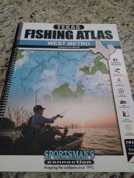
I bought a new map book at Wally World today. It seems to be a good publication.
![[Linked Image]](https://texasfishingforum.com/forums/pics/userpics/2021/07/full-111762-102813-img_20210708_155339792.jpg)

There is also an east edition. They are in a large format, like an old style road atlas. They contain lots of information about area lakes, facilities, and fishing information. It looks like they did a lot of coordination to put them together. There are books for other areas of the state still pending.
Some participants on this forum got pictures in the books.
Navionics maps are the the only Maps I use. I game plan and pin my areas on the navionics app before I travel fish and I can whip out my phone when on the water and have all my pins at my finger tips. I do have a huge bone to pick with navionics as their submerged timber is not marked worth a flip. Seems like that would be an easy fix but those yahoo’s can’t seem to get that figured out.
Posted By: Catfish Tim
Re: Fishing Atlas - 07/10/21 12:45 PM
I think my next map is going to be C Maps. My Navionics chart isn't accurate at all. I mean at all. The depth contours are off on Lavon by 10 feet or more all over the lake even when you adjust for high water. The shore line isn't accurate and the underwater features are way off too. It's close in general but when you are looking for structure that will hold fish... it doesn't do a good job. Just my opinion...
Are you using the sonar chart or the nautical chart on your phone App Tim? The sonar chart is much more accurate than the nautical chart. You also have to update your navionics card in your sonar unit yearly as the sonar charts change due to anglers uploading their data. Most anglers don’t update their charts or their firmware on their unit and they are constantly updating those things. Navionics on Lewisville used to show all kinds of structure that isn’t there. My last few updates increased my map accuracy 10 fold and the new maps no longer have that ghost structure. I know Lavon maps have been off by 10 ft on the deep part of the lake. I’m wondering if you update your map if it will correct your problem.
Posted By: Catfish Tim
Re: Fishing Atlas - 07/10/21 01:57 PM
Are you using the sonar chart or the nautical chart on your phone App Tim? The sonar chart is much more accurate than the nautical chart. You also have to update your navionics card in your sonar unit yearly as the sonar charts change due to anglers uploading their data. Most anglers don’t update their charts or their firmware on their unit and they are constantly updating those things. Navionics on Lewisville used to show all kinds of structure that isn’t there. My last few updates increased my map accuracy 10 fold and the new maps no longer have that ghost structure. I know Lavon maps have been off by 10 ft on the deep part of the lake. I’m wondering if you update your map if it will correct your problem.
I have not updated since I started keeping the boat at the marina. I need to figure out a way to do that...
Here is the difference between the nautical chart and the sonar chart on Lavon. Not a huge difference but structure is much more accurate on sonar chart.
![[Linked Image]](https://texasfishingforum.com/forums/pics/userpics/2021/07/full-99544-102971-54034437_94f1_4ddb_8f38_eeb19a4db87b.png)
![[Linked Image]](https://texasfishingforum.com/forums/pics/userpics/2021/07/full-99544-102972-e39f164f_5eb4_40a9_8303_27f2ef03abe2.png)
Posted By: Catfish Tim
Re: Fishing Atlas - 07/10/21 03:14 PM
Looks like I've been doing a bit of the old floating around like an idiot... That's what I like about you Chris, you are always teaching me something...
![[Linked Image]](https://texasfishingforum.com/forums/pics/userpics/2021/07/full-111762-102813-img_20210708_155339792.jpg)

![[Linked Image]](https://texasfishingforum.com/forums/pics/userpics/2021/07/full-111762-102813-img_20210708_155339792.jpg)

![[Linked Image]](https://texasfishingforum.com/forums/pics/userpics/2021/07/full-111762-102813-img_20210708_155339792.jpg)

![[Linked Image]](https://texasfishingforum.com/forums/pics/userpics/2021/07/full-99544-102971-54034437_94f1_4ddb_8f38_eeb19a4db87b.png)
![[Linked Image]](https://texasfishingforum.com/forums/pics/userpics/2021/07/full-99544-102972-e39f164f_5eb4_40a9_8303_27f2ef03abe2.png)