Texas Fishing Forum

where to start-topo map and link attached

Posted By: zachary00

where to start-topo map and link attached - 08/18/19 03:33 AM

I recently started a thread about getting back to basics. One of the suggestions that has stuck with me was study a topo map. Due to my lack of confidence, I am seeking input. There is such a wealth of knowledge on here, I would be remiss to not at least ask. Worst thing that can happen is everyone ignores it and it goes to the bottom... Attached is a pic of a topo map I for the lake I fish the most, and the link to the navionics webapp is here (if it works).

This lake has a lot of bull rush around the shallow areas, but not to much in the shallows near the deep water. Other than an old water line that runs off the inactive power plant that I can see on the si, the bottom seems to be pretty barren and mostly mud. not enough pads or grass to get excited about.

My understanding of bass, I should be looking for shallow water near deep water. With that in mind, it seems to me I should start around the flats on the north and south side of the channel near the dam that has the deep water close by.

Am I right, or should I start somewhere else (assuming I was going fishing tomorrow)? How far will a bass travel from deep water to feed in the shallow water?
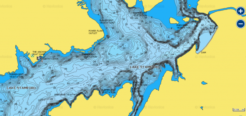
Attached picture stamford topo.png
Posted By: Capt. Bryan

Re: where to start-topo map and link attached - 08/18/19 05:01 AM

I would likely launch and start idling across a couple of points at different depths to see what depth baitfish is located. Then start locating areas that same depth. Since there is not much grass look for rock or timber. Check tpw website to see if it is a lake that they have put brushpiles into. The first two things that call my attention are the two humps out in the lake. One on left side of your map south of the boat ramp and the other is above the L in lake. The one above the L has a horseshoe cut on the south side of it and another drain on north side. I would likely target 12-15 foot depending on bait and thermo line. I would have a crankbait, c-rig and drop shot tied on. Other than that I would be graphing anywhere the contour lines get tight and appear as a dark area knowing those areas are steeper drops from shallow to deep.
Posted By: Donald Harper

Re: where to start-topo map and link attached - 08/18/19 02:17 PM

The lake is full of areas right next to 20 ft. of water which is a PLUS. I always look at the contour lines beyond that depth to the closest channel to determine the irregularity and the routes bass will use to move that short distance to the slopes to feed. This lake does not have that with the average depth being around 23 feet. Bass that live in shallow water lakes get acclimated to the hotter shallower water; but move around a lot as the food source is depleted. Your difference here is all the areas that drop off fast to that average depth. Just concentrate on those best areas first. Look at the Low Water Images of these areas to find any Irregular Features sitting on the slopes, gouges, protrusions, rock piles, brush piles and the last brush lines on the best slopes. Then work the best shallow water areas that does have the heaviest shoreline cover even if deeper water is not close by. Bass that have no other choice will surprise you. Bass use what they have to ambush for feeding and will show up in the shallowest of areas. The next day they are gone. Deep water lakes that provide deep water contour lines to study can produce super areas that will hold fish on a consistent year round basis; but we have to study what we have.

I will be posting a long article in a few minutes titled; "Developing A System". I hope you will read it and pull what you can use to help you on your shallow water lake.
Posted By: David Burton

Re: where to start-topo map and link attached - 08/19/19 03:12 AM

There are resident shallow fish, resident deep fish, and everything in between. Fish your strengths. I would fish the bullrushes near rock, rip-rap, or standing timber. Then again, I have more confidence in the shallow fish regardless of time of year.

DB
Posted By: spacejunkie

Re: where to start-topo map and link attached - 08/20/19 12:53 PM

If I told you where to go that would be the places not to fish.
Posted By: White Oak Skeeter

Re: where to start-topo map and link attached - 08/20/19 04:19 PM

Using you Navionics map, I'd suggest using the chart viewer to enlarge the lake to see areas with the most severe drops that go from 12-18' of water down to 25' quickly and follow those contour lines with a texas rig, carolina rig, and/or drop shot. I see some really nice looking non-obvious points on the southwest end of the lake that I'd graph. But, that entire northeast side of the lake has a ton of sharp drops that I would bet serve as highways for baitfish and bass. If I had no clue on this lake, I'd start to the southwest, south, and northeast sides of those three islands in 15-25' of water looking for baitfish and bass lying close to the bottom. I would spend several hours up on the northeast side of the lake. As much as I love shallow fishing, there's enough deeper water on the lake to make me believe you can find cooler water and fish in those 20' deep plus areas.
© 2024 Texas Fishing Forum