Texas Fishing Forum

Hubbard Creek help

Posted By: Grassbass

Hubbard Creek help - 06/01/17 04:44 PM

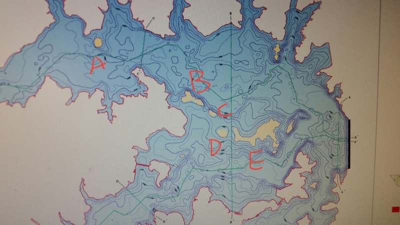
Hi folks, wondering if y'all could help me try to figure out a lake map of Hubbard Creek. The water level has changed so much, and I've never been on it, but I'm considering giving it a try. I know the coves are pretty good, but what I'm looking for are just the names of the islands. I've lettered them A-E. I should would appreciate it if you could help me with their names. This is an old Texas Water Development Board map I found, and it sure looks a lot different than Google Earth! Thanks for your help!

Posted By: Bass&More

Re: Hubbard Creek help - 06/01/17 05:03 PM

welcome to the TFF Grassbass
Posted By: Ted Martin

Re: Hubbard Creek help - 06/01/17 09:02 PM

Island E looks like a cartoon kangaroo with a slipped disc and some junk in the trunk. Just call it kangaroo island.
Posted By: Fish Killer

Re: Hubbard Creek help - 06/01/17 09:07 PM

between C and D is ft worth Cut
Posted By: SpikeStoker

Re: Hubbard Creek help - 06/01/17 09:23 PM

Between B and C is Ft worth cut. E is Long Island
Posted By: aggieangler03

Re: Hubbard Creek help - 06/02/17 12:01 AM

Originally Posted By: SpikeStoker
Between B and C is Ft worth cut. E is Long Island


Don't trust this guy. He's never even been there.
Posted By: Chris Borden

Re: Hubbard Creek help - 06/02/17 01:37 AM

Originally Posted By: aggieangler03
Originally Posted By: SpikeStoker
Between B and C is Ft worth cut. E is Long Island


Don't trust this guy. He's never even been there.


Man crush?
Posted By: TX Champ

Re: Hubbard Creek help - 06/02/17 01:30 PM

At normal pool, C & D are part of E
Posted By: 361V

Re: Hubbard Creek help - 06/02/17 01:41 PM

Originally Posted By: TX Champ
At normal pool, C & D are part of E
So with Hubbard showing only about 1/2' low these are actually one big island and only become individual islands when well above full? And how long ago would that have been?
Posted By: JG ZX250

Re: Hubbard Creek help - 06/02/17 01:47 PM

HERE YOU GO:
A= Spade Island
The Tiny little island on your map to the right of E is Goat Island
BCDE are what I would call Long Island.
The Pump Station sits on Sayer Island.
East of E across the lake is Tanglewood Island.
Lastly, between A and B is The Island (only seen it out of water when the lake was at it's lowest.) But does have some old fences and dipping vats with some stairs on it.
Posted By: B.Hollingshead

Re: Hubbard Creek help - 06/02/17 06:29 PM

I forgot what the lake looks like
Posted By: Big hoss

Re: Hubbard Creek help - 06/02/17 07:06 PM

The bass are on that Long Island right now from 6-10 ft of water they are schooled up so if you catch one more then likely throw back in the same spot and you will catch another one you will see them swimming up with the bass you have hooked .. hydrilla is starting to grow on the dam side of the island and off of goat island!!
Posted By: catslayer

Re: Hubbard Creek help - 06/03/17 02:30 AM

Bout to catch a BUNCH of water sooo this will change
Posted By: 9094

Re: Hubbard Creek help - 06/03/17 02:51 AM

Originally Posted By: catslayer
Bout to catch a BUNCH of water sooo this will change


Naw, the storm got to the windmills west of Albany and split. We will get some but not much.
All of the big rains just north of us today go into the Brazos, none of it comes to HC.
Posted By: Grassbass

Re: Hubbard Creek help - 06/05/17 03:21 PM

Thanks for the help! I really appreciate it!
© 2024 Texas Fishing Forum