GPS - Understanding your Diagnostic View
For years, I overlooked the GPS Diagnostic View. I just felt like it was a screen that didnĺt tell me anything to help me fish better, but I was wrong. The Helix GPS screen can tell you a lot, if you are willing to take a little time and learn a bit of technological information. Much of this screenĺs terms isnĺt really explained in Humminbirdĺs manual, so when I was learning, I had to search the net to find it.
The Helix GPS Diagnostic View, which I will refer to as the GPS screen, is full of great information, but you have to decipher some of it. No complex mathematical formulas are required, just an understanding of some acronyms and their meanings.
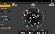
The GPS screen is divided into a satellite compass view and then a series of data blocks. Each data block provides key insight to an aspect of the userĺs unit and location and most importantly, your estimated position error at that moment.
I have included a copy of the screen from the current Helix manual.
In the image, the satellites are positioned around a compass of your position. Orbiting satellites are shown with their identification number, a strength meter, and a color. The amount of color visible in the color bar is the strength of the signal. The actual color indicates its status. Yellow indicates the satellite is actively involved in determining your position. A gray color (teal is used with Solix) indicates that your Helix in monitoring the satellite, but it is not involved in determining your global position. The more satellites that are actively being used and the farther apart in space they are, provides you better accuracy. Other key factors also play a part of your unitĺs accuracy.
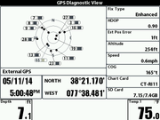
On the bottom left of the Helix screen are type of fix and the source, either internal or external GPS antenna. An enhanced fix means the unit is most likely using WAAS (Wide Area Augmentation System). WAAS was developed by the FAA to provide more precision for aircraft during flight and when using instrument landing. WAAS uses ground-based stations in North America which measure small changes to the satellite signals. This information determines any deviations in signals, corrects it and then sends it back into space to the satellites which then send updated information every 5 seconds. In short, if your unit is using the ENHANCED fix type, you are getting improved signal data.
Next is your current longitude and latitude location and last on the left side of the screen is the date and time.
On the right side of the GPS screen is a list of acronyms which once understood, is kind of cool to know and useful.
HDOP (Horizontal Dilution of Precision) ľ This is a factor that influences the error in a GPS fix. It is a measure of geometry between satellites being tracked and your unit.
< 1 is considered IDEAL.
2 to 3 is considered EXCELLENT.
2 to 5 is considered GOOD.
5 to 10 is considered MODERATE.
10 to 20 is considered FAIR.
> 20 is considered POOR.
Est Pos Error (Estimated Position Error) ľ This is the computed error that your unit believes exists at that moment. This is listed in feet. This number is subject to constant change as contributing factors change in the environment. It should be noted that this is only an estimated distance. A waypoint is a virtual marker that only exists on the screen of your GPS unit. When it was created, it had a degree of error in placement. When you return to it, your unit also has a degree of error. These two factors lead many to say that you return to an area, and never a specific spot.
Average CNO (Average Carrier-to-Noise ratio) ľ This number is based on a scale of 0 to 60 dBHz. The lower the number the less noise the unit detects and the better your unit will lock onto satellite signals. The higher the number the more noise present and the less successful the unit is locking onto a satellite signal. Your improved accuracy occurs with less noise. Types of noise include other radio frequency transmissions like radio, television, satellite, and other electromagnetic noise in the atmosphere.
Top 4 ľ ôIn GPS positions, a position valid only in the horizontal plane. Generally, this is a position computed from only 3 satellites, meaning that some factor must be constrained to make the solution valid. A typical method of permitting such solutions to be computed is to assume a fourth satellite located at the center of the Earth, whose pseudorange is equal to the local radius of the Earth plus the assumed altitude.ö I am unable to find any indication of what a low or high number value would indicate in relation to either a good or bad factor. (Definition courtesy of Inventek Systems)
Speed ľ The boatĺs speed at that time.
COG (Course Over Ground) ľ This is the boats Course Over Ground which means the direction of actual movement.
SD Card ľ This should provide an indicator of the memory size of the card and the amount of spaced used. In the example we see that 3.67 of 3.7 GB is used.
Chart Card ľ This informs the user to the current card being used. Some Humminbird models have 2 card slots available. Some users may have both a LakeMaster and a Navionics in their unit. In this case, the user can tell when map card the unit currently has selected.
While there is a lot of information presented on this screen, we really only need a few key pieces to get the best results. It is recommended to use a mapping system lake LakeMaster or Navionics is preferred over the base maps.
Ľ Notice the number and strength of the satellite signals.
Ľ Make sure that your unit is using an Enhanced fix.
Ľ Look at the HDOP number and see it is less than 1.
Ľ Look at the Average CNO and determine the number between 0 and 60 you have.
Ľ Look at the Est Pos Error and determine your estimated position error in feet.
It is said that 95% of the time your unit should have an estimate position error of 15 feet or less. If at various times, you feel your unit is not performing to that distance, you may want to consider an external antenna, or relocating or elevating your external antenna. If you have done everything possible to ensure that your unit/antenna has an uninterrupted visibility to the sky, then the error you have is the error you have to live with.

Tight lines!
Capt. Craig