texasfishingforum.com logo
Main Menu
Advertisement
Affiliates
Advertisement
Newest Members
jesseh413, Brad2587, C Man, Cameron Gose, Jetskirentals512
119184 Registered Users
Top Posters(All Time)
hopalong 121,070
TexDawg 119,800
Bigbob_FTW 95,347
John175☮ 85,919
Pilothawk 83,274
Bob Davis 82,397
Mark Perry 72,493
Derek 🐝 68,322
JDavis7873 67,416
Forum Statistics
Forums59
Topics1,038,962
Posts13,956,462
Members144,184
Most Online39,925
Dec 30th, 2023
Print Thread
Hummingbird Autochart Live ?'s #12751573 05/11/18 02:42 PM
Joined: Apr 2017
Posts: 416
H
H2ODawg67 Offline OP
Angler
OP Offline
Angler
H
Joined: Apr 2017
Posts: 416
I have a few questions on the Autochart Live. I have a 898. I have a couple small lakes (200-60p acres) that have timber on them and would have to map what I can now and map some later when either it is flooded or some of the timber falls.
1.Does it just work off of 2D or does it also use SI?
2.Will it work while fishing (starting and stopping) or do you have to dedicate time to mapping?
3.Can you do it in stages and then seam the maps together?
4.Can you chart on one graph then export to sd card and import to another graph? If so, can you import to a graph (898) that does not make autocharts?
5.Will it be effective if you have to zig zag through the timber?


Formerly H2ODawg
Re: Hummingbird Autochart Live ?'s [Re: H2ODawg67] #12751737 05/11/18 04:26 PM
Joined: Nov 2010
Posts: 5,099
W
Wayne P. Online Content
TFF Celebrity
Online Content
TFF Celebrity
W
Joined: Nov 2010
Posts: 5,099
Neither 898 has Auto Chart Live. You need at least an ONIX, SOLIX, or Helix to have that feature.

1. For contour mapping it uses 2D sonar for depth and GPS for location. Depth comes from the center of the sonar pulse.

2. Yes as long as you have it turned on.

3. Yes all data is blended.

4. To use it in other units, you need another unit that has Auto Chart Live and the data is transferred to a Zero Line Card memory card ONLY.

5. The route you take makes no difference except what is beneath the transducer is the only accurate part of any produced contour lines. The rest is fake (interpolated).

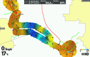
This is two tracks beside each other done with my Helix 12 SI GPS, note how wide the software makes the contours for a single path. All that to the sides is fake. All computer generated contour mapping does the same thing. Even the USGS map data is collected in intervals and contours are manually filled between data points (interpolated=fake).


You can use Recordings with your unit and process them with the computer software Auto Chart or Auto Chart Pro. Copy the created contour mapping to a Zero Line card, then the data is read as Lakemaster mapping by any unit that can read Lakemaster mapping.

I have Auto Chart Live contours on a single Zero Line Card that I did with my ONIX, SOLIX, Helix 5 DI GPS G2, Helix 7 SI GPS G2, and Helix 12 SI GPS.

Last edited by Wayne P.; 05/11/18 04:30 PM.

Helix 12 CHIRP MEGA SI+ GPS G3N and G4N, 1198c SI, SOLIX 10 SI G3,
Helix 8 MEGA SI+ GPS G4N, SOLIX 12 SI and G3, MEGA 360, MEGA LIVE TL, RC-1
Previous Thread
Index
Next Thread

© 1998-2022 OUTDOOR SITES NETWORK all rights reserved USA and Worldwide
Powered by UBB.threads™ PHP Forum Software 7.7.3