|
Forums59
Topics1,039,221
Posts13,961,163
Members144,196
| |
Most Online39,925
Dec 30th, 2023
|
|
 google map vs google earth vs bing map for bankers.
#11576024
05/01/16 04:24 AM google map vs google earth vs bing map for bankers.
#11576024
05/01/16 04:24 AM
|
Joined: Jan 2010
Posts: 1,138
Dunkky dude
 OP
OP
Extreme Angler
|
|
OP
Extreme Angler
Joined: Jan 2010
Posts: 1,138 |
Hi, i thought i would want to share this with you bankers in case if you didn't know already. To us banker fishmen, those tools are one of our best friends. even for boaters as well. But, there was one thing that really bothered me when i used them. satellite images are not real time. in fact, very outdated. that's not cool if you want to get an idea of geography of an area to locate some accessible spots. u see the spot and u drive one hour to find out that area you saw is now flooded.. Not cool. so, this what i found. 1. u gotta use google earth. 2. go to layer in the bottom right corner 3. unselect all and select only cloud and radar. 4. zoom in and view your map now. 5. u should see maps only few hours behind. 6. verdict, based on the image, i don't get to fish because the area is flooded. 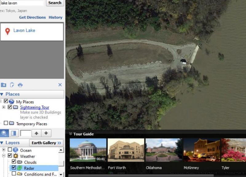
Last edited by Dunkky dude; 05/01/16 04:24 AM.
|
|
|
Re: google map vs google earth vs bing map for bankers.
[Re: Dunkky dude]
#11576032
05/01/16 04:32 AM
|
Joined: Jan 2016
Posts: 301
Kyhokie
Angler
|
|
Angler
Joined: Jan 2016
Posts: 301 |
The dude abides...
|
|
|
Re: google map vs google earth vs bing map for bankers.
[Re: Dunkky dude]
#11576034
05/01/16 04:33 AM
|
Joined: Jan 2010
Posts: 1,138
Dunkky dude
OP
Extreme Angler
|
|
OP
Extreme Angler
Joined: Jan 2010
Posts: 1,138 |
Same area, but two different outcome.. google earth vs google map.  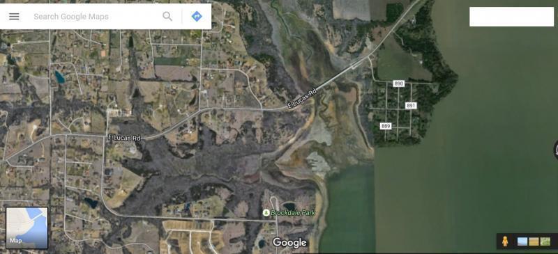
Last edited by Dunkky dude; 05/01/16 04:41 AM.
|
|
|
Re: google map vs google earth vs bing map for bankers.
[Re: Dunkky dude]
#11576502
05/01/16 05:14 PM
|
Joined: Apr 2014
Posts: 163
ZachW
Outdoorsman
|
|
Outdoorsman
Joined: Apr 2014
Posts: 163 |
This is a great tip- I had no idea you could get images that updated.
|
|
|
Re: google map vs google earth vs bing map for bankers.
[Re: ZachW]
#11576566
05/01/16 06:32 PM
|
Joined: Mar 2015
Posts: 702
BankAngler50
Pro Angler
|
|
Pro Angler
Joined: Mar 2015
Posts: 702 |
This is a great tip- I had no idea you could get images that updated. +1 and thanks for sharing Dunkky Dude. 
Why do I go fishing? To catch a box of fish and/or some quality time under the sun. Thank Heaven I never fail fishing in Texas, catching box fish or plenty of sunburn.
|
|
|
Re: google map vs google earth vs bing map for bankers.
[Re: Dunkky dude]
#11577343
05/02/16 02:27 AM
|
Joined: Jul 2013
Posts: 2,167
Fisherman13
Extreme Angler
|
|
Extreme Angler
Joined: Jul 2013
Posts: 2,167 |
Looks like the Highland park ramp at Lavon. And yes Lavon is quite high right now. I fished near Collin Park the other day in the kayak and was surprised how clear the water was. It is kinda muddy on the north end. Great tip on using google Earth!
By the way do you fish at Highland often? I live pretty close by and saw a guy catfishing from the bank there a while back just to the south of the ramp.
|
|
|
Re: google map vs google earth vs bing map for bankers.
[Re: Dunkky dude]
#11577398
05/02/16 02:57 AM
|
Joined: Jan 2010
Posts: 1,138
Dunkky dude
OP
Extreme Angler
|
|
OP
Extreme Angler
Joined: Jan 2010
Posts: 1,138 |
no problem guys. glad i can contribute little to help out the bankers. actually it will benefit the boaters too.
|
|
|
Re: google map vs google earth vs bing map for bankers.
[Re: Fisherman13]
#11577407
05/02/16 03:02 AM
|
Joined: Jan 2010
Posts: 1,138
Dunkky dude
OP
Extreme Angler
|
|
OP
Extreme Angler
Joined: Jan 2010
Posts: 1,138 |
Looks like the Highland park ramp at Lavon. And yes Lavon is quite high right now. I fished near Collin Park the other day in the kayak and was surprised how clear the water was. It is kinda muddy on the north end. Great tip on using google Earth!
By the way do you fish at Highland often? I live pretty close by and saw a guy catfishing from the bank there a while back just to the south of the ramp.
i tried a couple of times there as it is the closest from my home. I got only one for each trip which was either let go or gave to other banker fisherman, nothing to brag about. i was told that that spot can be productive, but for me it's hard to tell. I need to try this phantom minnows one of those days to see if that would change my luck. 
|
|
|
Re: google map vs google earth vs bing map for bankers.
[Re: Dunkky dude]
#11581120
05/03/16 10:22 PM
|
Joined: Aug 2013
Posts: 55
timid tiger
Outdoorsman
|
|
Outdoorsman
Joined: Aug 2013
Posts: 55 |
Actually, google earth doesn't update maps just every few hours. More like every few months to 1 year.
Selecting "weather layer" does not affect the actual satellite maps.
What google earth is beneficial is that you get to see historical satellite images. Some of the underwater structures are exposed during low water times when the images were taken.
|
|
|
Re: google map vs google earth vs bing map for bankers.
[Re: timid tiger]
#11583359
05/04/16 09:55 PM
|
Joined: Jan 2010
Posts: 1,138
Dunkky dude
OP
Extreme Angler
|
|
OP
Extreme Angler
Joined: Jan 2010
Posts: 1,138 |
logically, i don't see how that weather and cloud configuration made the difference. but for me it did. you can clearly tell, google map is way outdated. google earth showed me the same thing before I apply the configuration changes. i doubt the map shown above from GE is a year old where gm is.
|
|
|
Re: google map vs google earth vs bing map for bankers.
[Re: Dunkky dude]
#11594318
05/10/16 05:49 PM
|
Joined: Mar 2012
Posts: 472
TXfisherman12
Angler
|
|
Angler
Joined: Mar 2012
Posts: 472 |
This is a very interesting topic. I tried OP methods on a spot I hunted last week. When I use Google maps the only way to see satellite images is to click the "Earth" button in the bottom left hand corner. That will show me a map that is identical to which I see when searching using the program Google Earth. On my Google Earth map (with selecting the layers as OP mentions)the imagery date is listed as 4-11-2013. Another reason I know the Google Earth map is old because what is shown on the map as clear-cut fields are no longer clear-cut fields where I actually hunted last week. Checking or unchecking clouds and/or radar did not change the map for me.
So without any further information I would say that timid tiger's reply is supported (unless I am missing something?)
It was a different world when we were boys and girls....
|
|
|
Re: google map vs google earth vs bing map for bankers.
[Re: Dunkky dude]
#11657189
06/09/16 06:37 PM
|
Joined: Jul 2007
Posts: 104
agengo02
Outdoorsman
|
|
Outdoorsman
Joined: Jul 2007
Posts: 104 |
Not accurate. On the bottom portion of your Google Earth map next to the lat/long shows the imagery date. It is based off where your cursor is and only changes when they make updates on Google's end. The cloud coverage/radar only throws that info over top of the base map. As previously mentioned, it is useful for looking at historical maps to see things during a previous low tide. 
|
|
Moderated by banker-always fishing, chickenman, Derek 🐝, Duck_Hunter, Fish Killer, J-2, Jacob, Jons3825, JustWingem, Nocona Brian, Toon-Troller, Uncle Zeek, Weekender1
|