|
Forums59
Topics1,038,970
Posts13,956,632
Members144,184
| |
Most Online39,925
Dec 30th, 2023
|
|
 Re: Lake Grapevine Flood. Now with pics
[Re: trav1921]
#10866279
05/23/15 06:49 PM Re: Lake Grapevine Flood. Now with pics
[Re: trav1921]
#10866279
05/23/15 06:49 PM
|
Joined: Dec 2014
Posts: 1,665
Muzzlebrake

Extreme Angler
|
|
Extreme Angler
Joined: Dec 2014
Posts: 1,665 |
Another 8-1/2 ft and my Monday Tee time at Grapevine Municipal will be canceled.
From Genesis: "And God promised men that good and obedient wives would be found in all corners of the earth."
Then He made the earth round...and He laughed and laughed and laughed!
|
|
|
Re: Lake Grapevine Flood. Now with pics
[Re: trav1921]
#10866749
05/23/15 10:38 PM
|
Joined: Apr 2009
Posts: 5,923
BrianTx01
TFF Celebrity
|
|
TFF Celebrity
Joined: Apr 2009
Posts: 5,923 |
Might were some waterwings....that us a 63 year old earthen dam holding back 175% of its normal capacity.
Fighting Texas Aggie Class of 2001
Proud UNT Alumni
|
|
|
Re: Lake Grapevine Flood. Now with pics
[Re: trav1921]
#10868930
05/24/15 07:48 PM
|
Joined: Jan 2013
Posts: 2
Jelf
Green Horn
|
|
Green Horn
Joined: Jan 2013
Posts: 2 |
Below is a link to an online map that can display various layers of data for the USA about rain and floods. This data includes reports from trained weather spotters. These data layers are hosted on GIS (Geographical Information System) servers operated by NOAA and FEMA If you click on GIS data then you will see a popup with all the attribute data the GIS server has for the thing that you clicked. Sometimes that attribute data has a link you can follow for more information. These links can be very informative. For example, the �Stream_flow� layer has a link that usually displays a graph showing actual and forecast water flow levels at that gage. To see the map legends and learn how to turn other GIS layers on/off, click "About this map" in the upper left corner. If you turn on a GIS layer and do not see any data then (1) try zooming in and (2) wait a bit in case the server is busy. The map is displayed by Gmap4 which is an enhanced Google map viewer. I developed this browser app and provide it as a public service. If you open the map with a cell phone or other mobile device then you will see a touch-friendly interface. http://www.mappingsupport.com/p/gmap4.ph..._rain_flood.txt Joseph, the Gmap4 guy
|
|
|
Re: Lake Grapevine Flood. Now with pics
[Re: trav1921]
#10869463
05/25/15 12:27 AM
|
Joined: Apr 2009
Posts: 5,923
BrianTx01
TFF Celebrity
|
|
TFF Celebrity
Joined: Apr 2009
Posts: 5,923 |
18.5' above pool and rising.
Fighting Texas Aggie Class of 2001
Proud UNT Alumni
|
|
|
Re: Lake Grapevine Flood. Now with pics
[Re: trav1921]
#10870225
05/25/15 11:23 AM
|
Joined: Apr 2009
Posts: 5,923
BrianTx01
TFF Celebrity
|
|
TFF Celebrity
Joined: Apr 2009
Posts: 5,923 |
19'...finally started to open the gates.
Fighting Texas Aggie Class of 2001
Proud UNT Alumni
|
|
 Re: Lake Grapevine Flood. Now with pics
[Re: Jelf]
#10870309
05/25/15 12:46 PM Re: Lake Grapevine Flood. Now with pics
[Re: Jelf]
#10870309
05/25/15 12:46 PM
|
Joined: Aug 2008
Posts: 51
deepfried
Outdoorsman
|
|
Outdoorsman
Joined: Aug 2008
Posts: 51 |
Wow this map has a lot of good information built into it.
It took me a while to figure out the layers but now I see how to add the data that I am looking for.
Great job on the interface!
|
|
|
Re: Lake Grapevine Flood. Now with pics
[Re: trav1921]
#10874763
05/27/15 11:15 AM
|
Joined: Jan 2014
Posts: 500
GetSlimed
Pro Angler
|
|
Pro Angler
Joined: Jan 2014
Posts: 500 |
20.49' over. How high did it get in the 1982 flood?
PB Blue Cat 67lbs - Twok
2013 Blue Wave 2200 Pure Bay Yamaha 250
|
|
|
Re: Lake Grapevine Flood. Now with pics
[Re: trav1921]
#10874781
05/27/15 11:41 AM
|
Joined: Apr 2009
Posts: 5,923
BrianTx01
TFF Celebrity
|
|
TFF Celebrity
Joined: Apr 2009
Posts: 5,923 |
It was over the spillway...so 25'+.
Fighting Texas Aggie Class of 2001
Proud UNT Alumni
|
|
|
Re: Lake Grapevine Flood. Now with pics
[Re: trav1921]
#10874789
05/27/15 11:50 AM
|
Joined: Sep 2005
Posts: 581
Outfitter Nomore
Pro Angler
|
|
Pro Angler
Joined: Sep 2005
Posts: 581 |
Nov.1st 1981 it reached 563.6 ft. It should go over spillway at 560ft.
|
|
|
Re: Lake Grapevine Flood. Now with pics
[Re: trav1921]
#10875497
05/27/15 04:35 PM
|
Joined: Dec 2014
Posts: 1,665
Muzzlebrake
Extreme Angler
|
|
Extreme Angler
Joined: Dec 2014
Posts: 1,665 |
Back in 81 when it went over it took out the road and exposed some dinosaur bones down the gully a ways. The ARKY-ologist tree huggers descended on the area and it was years before they rebuilt the road and spillway while these people excavated the reptiles old bones. People in Flower Mound had a real inconvenience handed to them since there was no way to get across the dam into their neighborhoods.
From Genesis: "And God promised men that good and obedient wives would be found in all corners of the earth."
Then He made the earth round...and He laughed and laughed and laughed!
|
|
|
Re: Lake Grapevine Flood. Now with pics
[Re: trav1921]
#10875534
05/27/15 04:52 PM
|
Joined: Apr 2009
Posts: 5,923
BrianTx01
TFF Celebrity
|
|
TFF Celebrity
Joined: Apr 2009
Posts: 5,923 |
I would expect the Grapevine ramps will be closed for an extended period of time after the water goes down. Last time in 2007 they opened them back up almost immediately. It took them years to get the parking lot lights fixed....but this has been a bigger flood.
Fighting Texas Aggie Class of 2001
Proud UNT Alumni
|
|
|
Re: Lake Grapevine Flood. Now with pics
[Re: trav1921]
#10877940
05/28/15 02:27 PM
|
Joined: Sep 2005
Posts: 581
Outfitter Nomore
Pro Angler
|
|
Pro Angler
Joined: Sep 2005
Posts: 581 |
Lake will stay closed after the water goes down. The ground under the roads and parking lots must dry out before traffic is allowed on the surface or the surface will break and crumble. 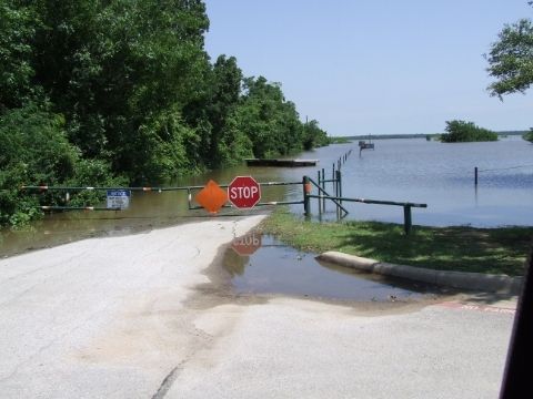 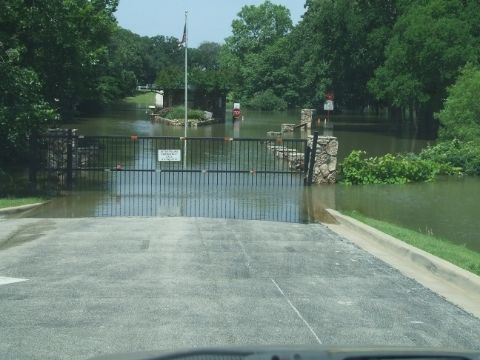 Road to dove Rd. Ramp Entrance to RV Park
|
|
|
Re: Lake Grapevine Flood. Now with pics
[Re: trav1921]
#10879942
05/29/15 06:52 AM
|
Joined: Jun 2013
Posts: 131
trav1921
OP
Outdoorsman
|
|
OP
Outdoorsman
Joined: Jun 2013
Posts: 131 |
I rode out with my brother the grapevine cop last night.Its terrible out there. We tried to go check out our boat. It will be weeks if not a month or more before we can get anywhere near the boat. Interestingly enough we came across a herd of feral hogs and about 20 does hanging out at the soccer fields off Dove Loop rd. Crazy out there.
|
|
|
Re: Lake Grapevine Flood. Now with pics
[Re: trav1921]
#10880035
05/29/15 11:31 AM
|
Joined: Jan 2014
Posts: 500
GetSlimed
Pro Angler
|
|
Pro Angler
Joined: Jan 2014
Posts: 500 |
And we got another 3" of rain last night at DFW airport.
PB Blue Cat 67lbs - Twok
2013 Blue Wave 2200 Pure Bay Yamaha 250
|
|
|
Re: Lake Grapevine Flood. Now with pics
[Re: trav1921]
#10881225
05/29/15 07:05 PM
|
Joined: Apr 2009
Posts: 5,923
BrianTx01
TFF Celebrity
|
|
TFF Celebrity
Joined: Apr 2009
Posts: 5,923 |
22.5' high...coe has started letting some water on now... But I can't see them doing it much longer wish cause the Elm Form is full. I took this pic from Riverside Drive in Las Colinas. 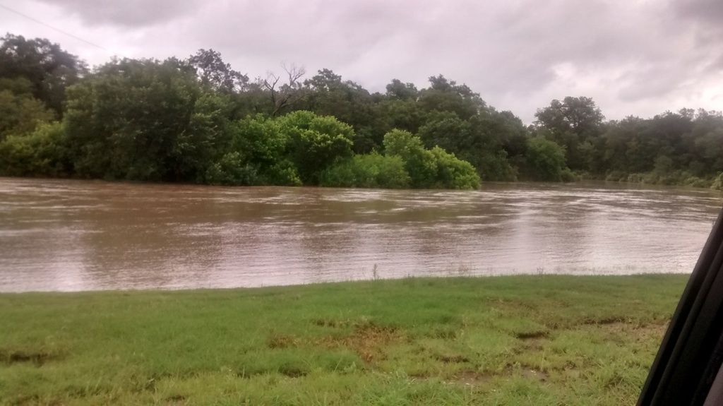
Fighting Texas Aggie Class of 2001
Proud UNT Alumni
|
|
Moderated by banker-always fishing, chickenman, Derek 🐝, Duck_Hunter, Fish Killer, J-2, Jacob, Jons3825, JustWingem, Nocona Brian, Toon-Troller, Uncle Zeek, Weekender1
|
![[Linked Image]](http://i1337.photobucket.com/albums/o666/notrees/c9ce0e94-e23c-4b47-83c1-d16683a23582_zps7e390d63.jpg)


